Import a GPX file

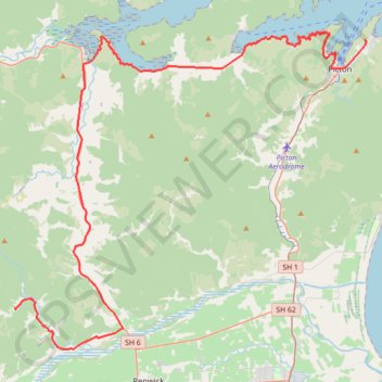
Picton - Onamalutu Campsite

Kaituna River, Wairau River, Ōhinemahuta River. #Bike #Road #Sea #Mountain #River #Nature

  • Distance: 45.2 mi
  • Elevation gain: 4,806 ft
  • Maximum elevation: 509 ft
  • Elevation loss: 4,521 ft
  • Minimum elevation: 3 ft

Interactive trail map

Trail profile

  • Distance: 45.2 mi
  • Elevation gain: 4,806 ft
  • Maximum elevation: 509 ft
  • Elevation loss: 4,521 ft
  • Minimum elevation: 3 ft

About this trail
Other hiking, mountain biking, running and outdoor activity trails

Click on a trail to view its statistics, map and profile.
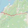
Havelock - Nelson

New Zealand > Marlborough > Marlborough District > Havelock

#Bike #MTB #Mountain #River #Lake #Sea #Forest #Nature

Distance: 38.5 mi • Elevation gain: 5,407 ft • Maximum elevation: 2,441 ft

Onamalutu Campsite - Saint Arnaud

New Zealand > Marlborough > Marlborough District

Wairau River, Lake Rotoiti #Bike #River #Forest #Mountain #Lake #Nature

Distance: 60.7 mi • Elevation gain: 4,859 ft • Maximum elevation: 2,421 ft

Takorika Summit loop - Havelock

New Zealand > Marlborough > Marlborough District > Havelock

Distance: 6.2 mi • Elevation gain: 2,487 ft • Maximum elevation: 2,310 ft

Gear up for your next adventure:

🪶Compact Camp Shovel - Folding shovel for campsite tasks
🔭Stargazing Telescopes - Perfect for camping in low-light pollution areas shown on maps
🧭Map Reading Tools - Tools and kits for map navigation
🧤Tactile Hiking Gloves - Keep hands warm while operating GPS and smartphone screens
❄️Traction Cleats - Prevent slips on icy trails during winter hikes

As an Amazon Associate, this site earns from qualifying purchases at no extra cost to you.