Make a donation
Gear up for your next adventure:
As an Amazon Associate, this site earns from qualifying purchases at no extra cost to you.
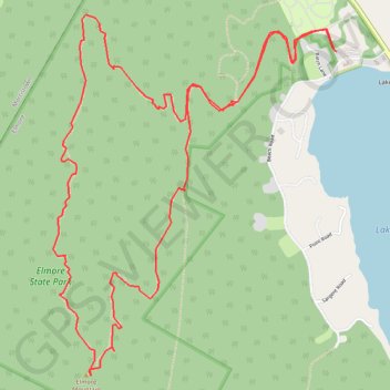
Elmore Mountain Loop
Loop hike from Lake Elmore to Elmore Mountain via Ridge Trail and Fire Tower Trail in the Elmore State Park. #Hiking #Loop #Mountain #Nature #Lake #Forest #Park
- Distance: 5.6 mi
- Elevation gain: 1,512 ft
- Maximum elevation: 2,572 ft
- Elevation loss: 1,512 ft
- Minimum elevation: 1,158 ft
- Moving time: 2 h 14 m
- Moving speed: 2.5 mph
- Maximum speed: 4.0 mph
- Total time: 2 h 31 m
- Global speed: 2.2 mph
Interactive trail map
Make a donation
Gear up for your next adventure:
As an Amazon Associate, this site earns from qualifying purchases at no extra cost to you.
Trail profile
- Distance: 5.6 mi
- Elevation gain: 1,512 ft
- Maximum elevation: 2,572 ft
- Elevation loss: 1,512 ft
- Minimum elevation: 1,158 ft
- Moving time: 2 h 14 m
- Moving speed: 2.5 mph
- Maximum speed: 4.0 mph
- Total time: 2 h 31 m
- Global speed: 2.2 mph
Make a donation
Gear up for your next adventure:
As an Amazon Associate, this site earns from qualifying purchases at no extra cost to you.
About this trail
Name: Elmore Mountain Loop trail, distance, elevation, map, profile, GPS track
Start: Beach Road, Lake Elmore, Elmore, Lamoille County, Vermont, 05657, United States (44.54239 -72.52895)
End: Beach Road, Lake Elmore, Elmore, Lamoille County, Vermont, 05657, United States (44.54241 -72.52903)
Coordinates: 44.52639 -72.54859 44.54422 -72.52895
Topography: Elmore topographic map, elevation, terrain
Make a donation
Gear up for your next adventure:
As an Amazon Associate, this site earns from qualifying purchases at no extra cost to you.
Other hiking, mountain biking, running and outdoor activity trails
Click on a trail to view its statistics, map and profile.