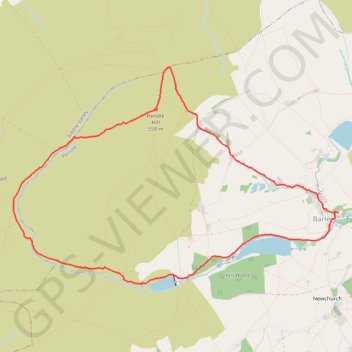
Pendle Hill Loop
Loop hike from Barley via Pendle Hill, Ogden Clough, Upper Ogden Reservoir, Buttock Plantation and Lower Ogden Reservoir in the Forest of Bowland National Landscape. #Hiking #Loop #Nature #Countryside #River #Lake #Forest
- Distance: 5.9 mi
- Elevation gain: 1,135 ft
- Maximum elevation: 1,827 ft
- Elevation loss: 1,129 ft
- Minimum elevation: 722 ft
- Moving time: 2 h 54 m
- Moving speed: 2.0 mph
- Maximum speed: 4.6 mph
- Total time: 3 h 10 m
- Global speed: 1.9 mph
Interactive trail map
Trail profile
- Distance: 5.9 mi
- Elevation gain: 1,135 ft
- Maximum elevation: 1,827 ft
- Elevation loss: 1,129 ft
- Minimum elevation: 722 ft
- Moving time: 2 h 54 m
- Moving speed: 2.0 mph
- Maximum speed: 4.6 mph
- Total time: 3 h 10 m
- Global speed: 1.9 mph
About this trail
Name: Pendle Hill Loop trail, distance, elevation, map, profile, GPS track
Coordinates: 53.85239 -2.32087 53.87251 -2.26992
Other hiking, mountain biking, running and outdoor activity trails
Click on a trail to view its statistics, map and profile.
Up and down Pendle Hill
United Kingdom > England > Lancashire > Borough of Pendle > Barley
Distance: 4.3 mi • Elevation gain: 1,112 ft • Maximum elevation: 1,831 ft