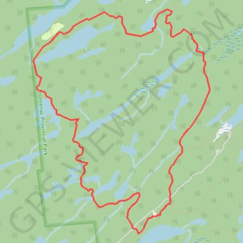
Import a GPX file

Arkon Lake Loop

Frontenac Provincial Park. #Hiking #Snowshoeing #Loop #Frontenac

  • Distance: 6.1 mi
  • Elevation gain: 404 ft
  • Maximum elevation: 627 ft
  • Elevation loss: 404 ft
  • Minimum elevation: 518 ft

Interactive trail map

Trail profile

  • Distance: 6.1 mi
  • Elevation gain: 404 ft
  • Maximum elevation: 627 ft
  • Elevation loss: 404 ft
  • Minimum elevation: 518 ft

About this trail

Other hiking, mountain biking, running and outdoor activity trails

Click on a trail to view its statistics, map and profile.

Adolphustown - Brockville

Canada > Ontario > Lennox and Addington County > Greater Napanee

Lake Ontario. #Bike #Ontario

Distance: 81.7 mi • Elevation gain: 2,267 ft • Maximum elevation: 364 ft

Québec - Montréal - Saint-Laurent River - Lake Ontario - Niagara Falls

Canada > Quebec > Urban agglomeration of Québec > Quebec

#Bike #Ontario

Distance: 670.1 mi • Elevation gain: 15,761 ft • Maximum elevation: 686 ft

Gear up for your next adventure:

🌡️Portable Weather Meter - Track weather conditions on the trail
🚁Photography Drones - Capture stunning aerial views of landforms and topography
🛡️Bear Spray Outdoor - Protection in bear country hikes
🗻Climbing Gear Basics - Essential gear for beginner climbers
🕶️GPS Smartphone Mount - Secure mount for phone navigation

As an Amazon Associate, this site earns from qualifying purchases at no extra cost to you.