Wadsworth Falls Loop Trail in Wadsworth Falls State Park
The Wadsworth Falls Loop Trail offers a scenic journey through a beautiful wooded landscape, making it an ideal destination for nature enthusiasts. Hikers can enjoy picturesque views of the impressive Wadsworth Falls, a striking 30-foot waterfall, as well as smaller cascades along the route, which are particularly captivating after rainfall. The trail is well-marked and suitable for families, providing a peaceful atmosphere and opportunities for birdwatching, with the backdrop of the Coginchaug River enhancing the overall experience. #Hiking #Loop #Waterfall #Forest #Nature
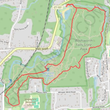
- Distance: 3.7 mi
- Elevation gain: 302 ft
- Maximum elevation: 259 ft
- Elevation loss: 299 ft
- Minimum elevation: 79 ft
- Moving time: 1 h 28 m
- Moving speed: 2.5 mph
- Maximum speed: 3.6 mph
- Total time: 1 h 41 m
- Global speed: 2.2 mph
Interactive trail map
Trail profile
- Distance: 3.7 mi
- Elevation gain: 302 ft
- Maximum elevation: 259 ft
- Elevation loss: 299 ft
- Minimum elevation: 79 ft
- Moving time: 1 h 28 m
- Moving speed: 2.5 mph
- Maximum speed: 3.6 mph
- Total time: 1 h 41 m
- Global speed: 2.2 mph
About this trail
Name: Wadsworth Falls Loop Trail in Wadsworth Falls State Park trail, distance, elevation, map, profile, GPS track
Coordinates: 41.52289 -72.69681 41.53675 -72.67856
Topography: Middletown topographic map, elevation, terrain