Blue Hen Falls via Buckeye Trail in Cuyahoga Valley National Park
The hike to Blue Hen Falls via the Buckeye Trail offers a picturesque journey through a lush forest landscape. This moderate trail features steep inclines and scenic views, leading hikers to the 15-foot waterfall, which is framed by various rock formations and mini-waterfalls above it. While the trail is popular and can be busy, it provides ample opportunities to appreciate the natural beauty of the park, especially during spring and fall when the foliage is vibrant. #Hiking #Waterfall #Forest #Nature
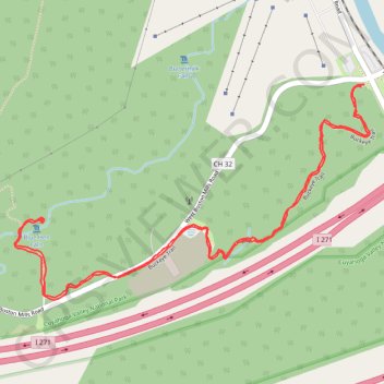
- Distance: 2.5 mi
- Elevation gain: 312 ft
- Maximum elevation: 909 ft
- Elevation loss: 318 ft
- Minimum elevation: 682 ft
- Moving time: 53 m 36 s
- Moving speed: 2.8 mph
- Maximum speed: 5.0 mph
- Total time: 1 h 2 m
- Global speed: 2.4 mph
Interactive trail map
Trail profile
- Distance: 2.5 mi
- Elevation gain: 312 ft
- Maximum elevation: 909 ft
- Elevation loss: 318 ft
- Minimum elevation: 682 ft
- Moving time: 53 m 36 s
- Moving speed: 2.8 mph
- Maximum speed: 5.0 mph
- Total time: 1 h 2 m
- Global speed: 2.4 mph
About this trail
Name: Blue Hen Falls via Buckeye Trail in Cuyahoga Valley National Park trail, distance, elevation, map, profile, GPS track
Coordinates: 41.25659 -81.57360 41.26226 -81.56115
Topography: Summit County topographic map, elevation, terrain
Other hiking, mountain biking, running and outdoor activity trails
Click on a trail to view its statistics, map and profile.
Blue Hen Falls via Buckeye Trail in Cuyahoga Valley National Park
United States > Ohio > Summit County > Boston
The hike to Blue Hen Falls via the Buckeye Trail in Cuyahoga Valley National Park offers an immersive journey through lush forested areas, where you’ll encounter serene streams, diverse wildlife, and the beauty of Ohio's natural landscapes. The trail leads to the iconic Blue Hen Falls, a lovely 15-foot…
Distance: 2.5 mi • Elevation gain: 351 ft • Maximum elevation: 909 ft