Thank you for supporting this site ❤️
Make a donation
Make a donation
Gear up for your next adventure:
As an Amazon Associate, this site earns from qualifying purchases at no extra cost to you.
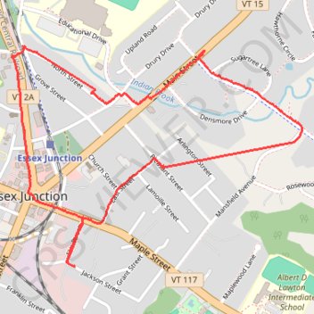
Walk around Essex Junction
- Distance: 2.5 mi
- Elevation gain: 85 ft
- Maximum elevation: 367 ft
- Elevation loss: 85 ft
- Minimum elevation: 331 ft
- Moving time: 54 m 49 s
- Moving speed: 2.7 mph
- Maximum speed: 20.6 mph
- Total time: 57 m 17 s
- Global speed: 2.6 mph
Interactive trail map
Thank you for supporting this site ❤️
Make a donation
Make a donation
Gear up for your next adventure:
As an Amazon Associate, this site earns from qualifying purchases at no extra cost to you.
Trail profile
- Distance: 2.5 mi
- Elevation gain: 85 ft
- Maximum elevation: 367 ft
- Elevation loss: 85 ft
- Minimum elevation: 331 ft
- Moving time: 54 m 49 s
- Moving speed: 2.7 mph
- Maximum speed: 20.6 mph
- Total time: 57 m 17 s
- Global speed: 2.6 mph
Thank you for supporting this site ❤️
Make a donation
Make a donation
Gear up for your next adventure:
As an Amazon Associate, this site earns from qualifying purchases at no extra cost to you.
About this trail
Name: Walk around Essex Junction trail, distance, elevation, map, profile, GPS track
Coordinates: 44.48799 -73.11209 44.49617 -73.09704
Topography: Chittenden County topographic map, elevation, terrain
Thank you for supporting this site ❤️
Make a donation
Make a donation
Gear up for your next adventure:
As an Amazon Associate, this site earns from qualifying purchases at no extra cost to you.
Other hiking, mountain biking, running and outdoor activity trails
Click on a trail to view its statistics, map and profile.