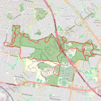
Mount Gravatt and Toohey Foret Loop
- Distance: 16.2 mi
- Elevation gain: 2,575 ft
- Maximum elevation: 614 ft
- Elevation loss: 2,569 ft
- Minimum elevation: 108 ft
- Moving time: 3 h 47 m
- Moving speed: 4.3 mph
- Maximum speed: 8.3 mph
- Total time: 4 h 4 m
- Global speed: 4.0 mph
Interactive trail map
Trail profile
- Distance: 16.2 mi
- Elevation gain: 2,575 ft
- Maximum elevation: 614 ft
- Elevation loss: 2,569 ft
- Minimum elevation: 108 ft
- Moving time: 3 h 47 m
- Moving speed: 4.3 mph
- Maximum speed: 8.3 mph
- Total time: 4 h 4 m
- Global speed: 4.0 mph
About this trail
Name: Mount Gravatt and Toohey Foret Loop trail, distance, elevation, map, profile, GPS track
Coordinates: -27.55515 153.03092 -27.53184 153.07955
Other hiking, mountain biking, running and outdoor activity trails
Click on a trail to view its statistics, map and profile.
Gravel loop ride via Karawatha
Australia > Queensland > City of Brisbane
Distance: 37.5 mi • Elevation gain: 2,034 ft • Maximum elevation: 361 ft
Toohey Forest Loop
Australia > Queensland > City of Brisbane
Distance: 4.9 mi • Elevation gain: 607 ft • Maximum elevation: 361 ft
Brisbane - Karawatha
Distance: 13.8 mi • Elevation gain: 784 ft • Maximum elevation: 292 ft