Make a donation
Gear up for your next adventure:
As an Amazon Associate, this site earns from qualifying purchases at no extra cost to you.
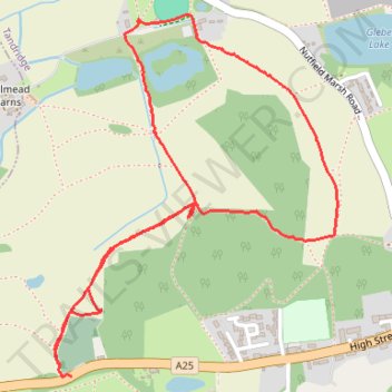
Walk on lanfilled quary land north of Nutfield Cemetery
- Distance: 2.3 mi
- Elevation gain: 226 ft
- Maximum elevation: 436 ft
- Elevation loss: 217 ft
- Minimum elevation: 269 ft
- Moving time: 1 h 7 m
- Moving speed: 2.1 mph
- Maximum speed: 4.2 mph
- Total time: 1 h 14 m
- Global speed: 1.9 mph
Interactive trail map
Make a donation
Gear up for your next adventure:
As an Amazon Associate, this site earns from qualifying purchases at no extra cost to you.
Trail profile
- Distance: 2.3 mi
- Elevation gain: 226 ft
- Maximum elevation: 436 ft
- Elevation loss: 217 ft
- Minimum elevation: 269 ft
- Moving time: 1 h 7 m
- Moving speed: 2.1 mph
- Maximum speed: 4.2 mph
- Total time: 1 h 14 m
- Global speed: 1.9 mph
Make a donation
Gear up for your next adventure:
As an Amazon Associate, this site earns from qualifying purchases at no extra cost to you.
About this trail
Name: Walk on lanfilled quary land north of Nutfield Cemetery trail, distance, elevation, map, profile, GPS track
Coordinates: 51.23816 -0.14143 51.24776 -0.12948
Make a donation
Gear up for your next adventure:
As an Amazon Associate, this site earns from qualifying purchases at no extra cost to you.
Other hiking, mountain biking, running and outdoor activity trails
Click on a trail to view its statistics, map and profile.
Loop Walk Earlswood, South Nutfield, Nutfield, Nutfield Marsh, Redhill
United Kingdom > England > Surrey > Reigate and Banstead > Redhill
Distance: 9.0 mi • Elevation gain: 522 ft • Maximum elevation: 476 ft
Walk Redhill to Hooley via The Moors Nature Reserve, South Mertstham, Tollsworth Manor, Alderstead Heath, Netherne-on-the-Hill
United Kingdom > England > Surrey > Reigate and Banstead > Redhill
Redhill, Hooley, South Mertstham, Alderstead Heath, Netherne-on-the-Hill
Distance: 6.7 mi • Elevation gain: 489 ft • Maximum elevation: 646 ft
Walk Earlswood to Nutfield March, via South Nutfield
United Kingdom > England > Surrey > Reigate and Banstead > Redhill
Distance: 7.1 mi • Elevation gain: 404 ft • Maximum elevation: 476 ft
Walk Earlswood, Merstham, Chaldon church, Fartyhing Downs, Coulson
United Kingdom > England > Surrey > Reigate and Banstead > Redhill
Distance: 10.2 mi • Elevation gain: 817 ft • Maximum elevation: 646 ft
Make a donation
Gear up for your next adventure:
As an Amazon Associate, this site earns from qualifying purchases at no extra cost to you.
Walk Earlswood to North Merstham, via Nutfirld Marsh, Brewer Street, Tylers Green Godstone, Gravelly Hill, North Downs Way
United Kingdom > England > Surrey > Reigate and Banstead > Redhill
Distance: 10.5 mi • Elevation gain: 771 ft • Maximum elevation: 761 ft
Walk Holmethorpe, Mersers Country Park, Nutfield Marsh, Beside expanded sand quarry
United Kingdom > England > Surrey > Reigate and Banstead > Merstham
Distance: 2.7 mi • Elevation gain: 49 ft • Maximum elevation: 295 ft
Walk Nutfield Marsh to Bletchingley via Mercer's Lake and Spynes Mere in Surrey Hills National Landscape
United Kingdom > England > Surrey > Reigate and Banstead > Redhill
Distance: 4.6 mi • Elevation gain: 371 ft • Maximum elevation: 502 ft
Walk Earlswood to Hooley
United Kingdom > England > Surrey > Reigate and Banstead > Redhill
South Merstham, Earlswood, Alderstead Heath, Netherne, Hooley
Distance: 7.7 mi • Elevation gain: 682 ft • Maximum elevation: 646 ft
Make a donation
Gear up for your next adventure:
As an Amazon Associate, this site earns from qualifying purchases at no extra cost to you.