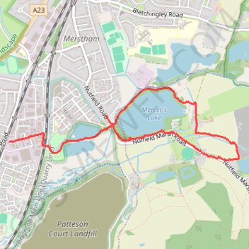
Walk Holmethorpe, Mersers Country Park, Nutfield Marsh, Beside expanded sand quarry
- Distance: 2.7 mi
- Elevation gain: 49 ft
- Maximum elevation: 295 ft
- Elevation loss: 69 ft
- Minimum elevation: 249 ft
- Moving time: 1 h 12 m
- Moving speed: 2.3 mph
- Maximum speed: 4.7 mph
- Total time: 1 h 17 m
- Global speed: 2.1 mph
Interactive trail map
Trail profile
- Distance: 2.7 mi
- Elevation gain: 49 ft
- Maximum elevation: 295 ft
- Elevation loss: 69 ft
- Minimum elevation: 249 ft
- Moving time: 1 h 12 m
- Moving speed: 2.3 mph
- Maximum speed: 4.7 mph
- Total time: 1 h 17 m
- Global speed: 2.1 mph
About this trail
Name: Walk Holmethorpe, Mersers Country Park, Nutfield Marsh, Beside expanded sand quarry trail, distance, elevation, map, profile, GPS track
Coordinates: 51.24746 -0.15936 51.25325 -0.12985
Other hiking, mountain biking, running and outdoor activity trails
Click on a trail to view its statistics, map and profile.
Loop Walk Earlswood, South Nutfield, Nutfield, Nutfield Marsh, Redhill
United Kingdom > England > Surrey > Reigate and Banstead > Redhill
Distance: 9.0 mi • Elevation gain: 522 ft • Maximum elevation: 476 ft
Walk Nutfield Marsh to Bletchingley via Mercer's Lake and Spynes Mere in Surrey Hills National Landscape
United Kingdom > England > Surrey > Reigate and Banstead > Redhill
Distance: 4.6 mi • Elevation gain: 371 ft • Maximum elevation: 502 ft
Walk Redhill to Hooley via The Moors Nature Reserve, South Mertstham, Tollsworth Manor, Alderstead Heath, Netherne-on-the-Hill
United Kingdom > England > Surrey > Reigate and Banstead > Redhill
Redhill, Hooley, South Mertstham, Alderstead Heath, Netherne-on-the-Hill
Distance: 6.7 mi • Elevation gain: 489 ft • Maximum elevation: 646 ft
Walk Earlswood, Merstham, Chaldon church, Fartyhing Downs, Coulson
United Kingdom > England > Surrey > Reigate and Banstead > Redhill
Distance: 10.2 mi • Elevation gain: 817 ft • Maximum elevation: 646 ft
Walk Earlswood to North Merstham, via Nutfirld Marsh, Brewer Street, Tylers Green Godstone, Gravelly Hill, North Downs Way
United Kingdom > England > Surrey > Reigate and Banstead > Redhill
Distance: 10.5 mi • Elevation gain: 771 ft • Maximum elevation: 761 ft
Walk Earlswood to Nutfield March, via South Nutfield
United Kingdom > England > Surrey > Reigate and Banstead > Redhill
Distance: 7.1 mi • Elevation gain: 404 ft • Maximum elevation: 476 ft
Walk on lanfilled quary land north of Nutfield Cemetery
United Kingdom > England > Surrey > South Nutfield
Distance: 2.3 mi • Elevation gain: 226 ft • Maximum elevation: 436 ft
Walk Colley Hill, Banstead Heath, Merstham
United Kingdom > England > Surrey > Reigate and Banstead > Reigate
Olley Hill, Banstead Heath, Merstham, Surrey
Distance: 10.5 mi • Elevation gain: 784 ft • Maximum elevation: 774 ft
Walk Earlswood to Hooley
United Kingdom > England > Surrey > Reigate and Banstead > Redhill
South Merstham, Earlswood, Alderstead Heath, Netherne, Hooley
Distance: 7.7 mi • Elevation gain: 682 ft • Maximum elevation: 646 ft