Make a donation
Gear up for your next adventure:
As an Amazon Associate, this site earns from qualifying purchases at no extra cost to you.
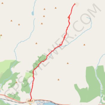
Munro Hillwalk Gulvain
Munro, hillwalk, Gulvain
- Distance: 14.9 mi
- Elevation gain: 4,062 ft
- Maximum elevation: 3,196 ft
- Elevation loss: 4,062 ft
- Minimum elevation: 33 ft
- Moving time: 5 h 36 m
- Moving speed: 2.7 mph
- Maximum speed: 12.2 mph
- Total time: 5 h 58 m
- Global speed: 2.5 mph
Interactive trail map
Make a donation
Gear up for your next adventure:
As an Amazon Associate, this site earns from qualifying purchases at no extra cost to you.
Trail profile
- Distance: 14.9 mi
- Elevation gain: 4,062 ft
- Maximum elevation: 3,196 ft
- Elevation loss: 4,062 ft
- Minimum elevation: 33 ft
- Moving time: 5 h 36 m
- Moving speed: 2.7 mph
- Maximum speed: 12.2 mph
- Total time: 5 h 58 m
- Global speed: 2.5 mph
Make a donation
Gear up for your next adventure:
As an Amazon Associate, this site earns from qualifying purchases at no extra cost to you.
About this trail
Name: Munro Hillwalk Gulvain trail, distance, elevation, map, profile, GPS track
Start: A861, Drumsallie, Highland, Scotland, PH33 7NP, United Kingdom (56.85964 -5.34897)
End: A861, Drumsallie, Highland, Scotland, PH33 7NP, United Kingdom (56.85965 -5.34893)
Coordinates: 56.85964 -5.34897 56.93626 -5.28452
Make a donation
Gear up for your next adventure:
As an Amazon Associate, this site earns from qualifying purchases at no extra cost to you.
Other hiking, mountain biking, running and outdoor activity trails
Click on a trail to view its statistics, map and profile.
Hike from Glenfinnan to A Chùil
United Kingdom > Scotland > Highland > Glenfinnan
Distance: 12.6 mi • Elevation gain: 2,451 ft • Maximum elevation: 1,634 ft