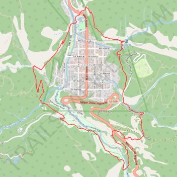
Ouray Perimeter Trail
Uncompahgre National Forest #Hiking #Loop #Mountain #Waterfall #Cliff #Forest #River
- Distance: 5.7 mi
- Elevation gain: 1,752 ft
- Maximum elevation: 8,494 ft
- Elevation loss: 1,752 ft
- Minimum elevation: 7,697 ft
- Moving time: 3 h 36 m
- Moving speed: 1.6 mph
- Maximum speed: 3.9 mph
- Total time: 5 h 18 m
- Global speed: 1.1 mph
Interactive trail map
Trail profile
- Distance: 5.7 mi
- Elevation gain: 1,752 ft
- Maximum elevation: 8,494 ft
- Elevation loss: 1,752 ft
- Minimum elevation: 7,697 ft
- Moving time: 3 h 36 m
- Moving speed: 1.6 mph
- Maximum speed: 3.9 mph
- Total time: 5 h 18 m
- Global speed: 1.1 mph
About this trail
Name: Ouray Perimeter Trail trail, distance, elevation, map, profile, GPS track
Start: Fellin Park Path, Ouray, Ouray County, Colorado, 81427, United States (38.02923 -107.67322)
End: Fellin Park Path, Ouray, Ouray County, Colorado, 81427, United States (38.02921 -107.67327)
Coordinates: 38.00865 -107.68058 38.03054 -107.66170
Topography: Ouray County topographic map, elevation, terrain
Other hiking, mountain biking, running and outdoor activity trails
Click on a trail to view its statistics, map and profile.
Ouray Perimeter Trail in Uncompahgre National Forest
United States > Colorado > Ouray County > Ouray
The Ouray Perimeter Trail offers hikers a scenic loop around the town of Ouray, Colorado, traversing diverse terrains including cliffs, canyons, and forested hillsides. Along the route, you'll encounter natural attractions such as Cascade Falls, the Baby Bath Tubs, and Box Canyon Falls, as well as panoramic…
Distance: 5.7 mi • Elevation gain: 1,722 ft • Maximum elevation: 8,494 ft