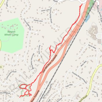
Pinecliff Audubon Sanctuary
- Distance: 3.3 mi
- Elevation gain: 479 ft
- Maximum elevation: 600 ft
- Elevation loss: 476 ft
- Minimum elevation: 361 ft
- Moving time: 1 h 6 m
- Moving speed: 3.0 mph
- Maximum speed: 5.2 mph
- Total time: 1 h 17 m
- Global speed: 2.6 mph
Interactive trail map
Trail profile
- Distance: 3.3 mi
- Elevation gain: 479 ft
- Maximum elevation: 600 ft
- Elevation loss: 476 ft
- Minimum elevation: 361 ft
- Moving time: 1 h 6 m
- Moving speed: 3.0 mph
- Maximum speed: 5.2 mph
- Total time: 1 h 17 m
- Global speed: 2.6 mph
About this trail
Name: Pinecliff Audubon Sanctuary trail, distance, elevation, map, profile, GPS track
Coordinates: 41.16530 -73.77299 41.17975 -73.76014
Topography: Westchester County topographic map, elevation, terrain
Other hiking, mountain biking, running and outdoor activity trails
Click on a trail to view its statistics, map and profile.