Thank you for supporting this site ❤️
Make a donation
Make a donation
Gear up for your next adventure:
As an Amazon Associate, this site earns from qualifying purchases at no extra cost to you.
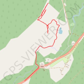
Pooteering around Edinchip
Walk around Edinchip
- Distance: 1.8 mi
- Elevation gain: 82 ft
- Maximum elevation: 669 ft
- Elevation loss: 282 ft
- Minimum elevation: 463 ft
- Moving time: 51 m 52 s
- Moving speed: 2.1 mph
- Maximum speed: 35.2 mph
- Total time: 1 h 1 m
- Global speed: 1.7 mph
Interactive trail map
Thank you for supporting this site ❤️
Make a donation
Make a donation
Gear up for your next adventure:
As an Amazon Associate, this site earns from qualifying purchases at no extra cost to you.
Trail profile
- Distance: 1.8 mi
- Elevation gain: 82 ft
- Maximum elevation: 669 ft
- Elevation loss: 282 ft
- Minimum elevation: 463 ft
- Moving time: 51 m 52 s
- Moving speed: 2.1 mph
- Maximum speed: 35.2 mph
- Total time: 1 h 1 m
- Global speed: 1.7 mph
Thank you for supporting this site ❤️
Make a donation
Make a donation
Gear up for your next adventure:
As an Amazon Associate, this site earns from qualifying purchases at no extra cost to you.
About this trail
Name: Pooteering around Edinchip trail, distance, elevation, map, profile, GPS track
Start: Kingshouse, Stirling, Scotland, FK19 8NZ, United Kingdom (56.36579 -4.31392)
End: A84, Kingshouse, Stirling, Scotland, FK19 8NX, United Kingdom (56.35753 -4.31717)
Coordinates: 56.35753 -4.31717 56.36782 -4.30888
Thank you for supporting this site ❤️
Make a donation
Make a donation
Gear up for your next adventure:
As an Amazon Associate, this site earns from qualifying purchases at no extra cost to you.
Other hiking, mountain biking, running and outdoor activity trails
Click on a trail to view its statistics, map and profile.