Thank you for supporting this site ❤️
Make a donation
Make a donation
Gear up for your next adventure:
As an Amazon Associate, this site earns from qualifying purchases at no extra cost to you.
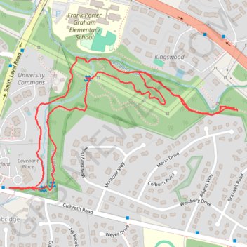
Morgan Creek Park
- Distance: 2.0 mi
- Elevation gain: 194 ft
- Maximum elevation: 430 ft
- Elevation loss: 194 ft
- Minimum elevation: 308 ft
- Moving time: 52 m 24 s
- Moving speed: 2.3 mph
- Maximum speed: 3.8 mph
- Total time: 1 h 28 m
- Global speed: 1.4 mph
Interactive trail map
Thank you for supporting this site ❤️
Make a donation
Make a donation
Gear up for your next adventure:
As an Amazon Associate, this site earns from qualifying purchases at no extra cost to you.
Trail profile
- Distance: 2.0 mi
- Elevation gain: 194 ft
- Maximum elevation: 430 ft
- Elevation loss: 194 ft
- Minimum elevation: 308 ft
- Moving time: 52 m 24 s
- Moving speed: 2.3 mph
- Maximum speed: 3.8 mph
- Total time: 1 h 28 m
- Global speed: 1.4 mph
Thank you for supporting this site ❤️
Make a donation
Make a donation
Gear up for your next adventure:
As an Amazon Associate, this site earns from qualifying purchases at no extra cost to you.
About this trail
Name: Morgan Creek Park trail, distance, elevation, map, profile, GPS track
Coordinates: 35.89363 -79.07553 35.89811 -79.06598
Topography: Chapel Hill topographic map, elevation, terrain
Thank you for supporting this site ❤️
Make a donation
Make a donation
Gear up for your next adventure:
As an Amazon Associate, this site earns from qualifying purchases at no extra cost to you.