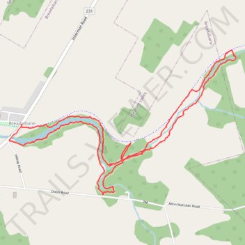
Breadalbane Nature Loop Trail
- Distance: 4.1 mi
- Elevation gain: 171 ft
- Maximum elevation: 171 ft
- Elevation loss: 174 ft
- Minimum elevation: 118 ft
- Moving time: 1 h 50 m
- Moving speed: 2.2 mph
- Maximum speed: 7.6 mph
- Total time: 2 h 2 m
- Global speed: 2.0 mph
Interactive trail map
Trail profile
- Distance: 4.1 mi
- Elevation gain: 171 ft
- Maximum elevation: 171 ft
- Elevation loss: 174 ft
- Minimum elevation: 118 ft
- Moving time: 1 h 50 m
- Moving speed: 2.2 mph
- Maximum speed: 7.6 mph
- Total time: 2 h 2 m
- Global speed: 2.0 mph
About this trail
Name: Breadalbane Nature Loop Trail trail, distance, elevation, map, profile, GPS track
Start: 2854, Inkerman Road, Breadalbane, Queens County, Prince Edward Island, Canada (46.35754 -63.50088)
End: Confederation Trail, Breadalbane, Queens County, Prince Edward Island, Canada (46.35732 -63.50098)
Coordinates: 46.35235 -63.50223 46.36294 -63.47825
Other hiking, mountain biking, running and outdoor activity trails
Click on a trail to view its statistics, map and profile.
Borden-Carleton - Charlottetown
Canada > Prince Edward Island > Town of Borden-Carleton > Borden-Carleton
Prince Edward Island. #Bike #BordenCarleton #Charlottetown #PrinceEdward
Distance: 40.5 mi • Elevation gain: 1,194 ft • Maximum elevation: 308 ft