Make a donation
Gear up for your next adventure:
As an Amazon Associate, this site earns from qualifying purchases at no extra cost to you.
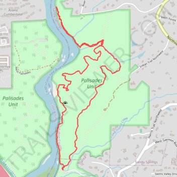
East Palisades and Bamboo Forest Loop Trail
The East Palisades and Bamboo Forest Loop Trail in the Chattahoochee River National Recreation Area offers hikers a scenic journey through diverse landscapes. As you traverse the trail, you'll encounter the towering bamboo forest—a unique and unexpected feature in Georgia—that creates a serene atmosphere reminiscent of a far-off land. The path also provides stunning views of the Chattahoochee River's Palisades section, characterized by sharply angular rock formations and frequented by kayakers navigating its gentle rapids. #Hiking #Loop #Forest #River #Nature
- Distance: 4.4 mi
- Elevation gain: 673 ft
- Maximum elevation: 1,017 ft
- Elevation loss: 673 ft
- Minimum elevation: 764 ft
- Moving time: 1 h 34 m
- Moving speed: 2.8 mph
- Maximum speed: 6.3 mph
- Total time: 1 h 36 m
- Global speed: 2.7 mph
Interactive trail map
Make a donation
Gear up for your next adventure:
As an Amazon Associate, this site earns from qualifying purchases at no extra cost to you.
Trail profile
- Distance: 4.4 mi
- Elevation gain: 673 ft
- Maximum elevation: 1,017 ft
- Elevation loss: 673 ft
- Minimum elevation: 764 ft
- Moving time: 1 h 34 m
- Moving speed: 2.8 mph
- Maximum speed: 6.3 mph
- Total time: 1 h 36 m
- Global speed: 2.7 mph
Make a donation
Gear up for your next adventure:
As an Amazon Associate, this site earns from qualifying purchases at no extra cost to you.
About this trail
Name: East Palisades and Bamboo Forest Loop Trail trail, distance, elevation, map, profile, GPS track
Start: East Palisades, Atlanta, Fulton County, Georgia, 30339, United States (33.87797 -84.44210)
End: East Palisades, Atlanta, Fulton County, Georgia, 30339, United States (33.87797 -84.44216)
Coordinates: 33.87797 -84.44301 33.89506 -84.43492
Topography: Atlanta topographic map, elevation, terrain
Make a donation
Gear up for your next adventure:
As an Amazon Associate, this site earns from qualifying purchases at no extra cost to you.
Other hiking, mountain biking, running and outdoor activity trails
Click on a trail to view its statistics, map and profile.
East Palisades and Bamboo Forest Loop
United States > Georgia > Fulton County > Atlanta
Starting from the Whitewater Creek side of the East Palisades unit, this loop follows the wooded bank of the Chattahoochee River upstream, passing rocky river edges, small islands, and open views across the water. At the northern end of the route, the path reaches the Bamboo Forest, a distinctive riverside…
Distance: 4.4 mi • Elevation gain: 666 ft • Maximum elevation: 1,017 ft
Bamboo Forest via East Palisades Loop in Chattahoochee River National Recreation Area
United States > Georgia > Fulton County > Atlanta
The Bamboo Forest via East Palisades Loop offers a unique hiking experience that brings you close to nature while being conveniently located near Atlanta. Hikers can enjoy views of the Chattahoochee River, traverse through a small but enchanting bamboo forest, and explore sections with striking rock…
Distance: 4.1 mi • Elevation gain: 617 ft • Maximum elevation: 1,017 ft
Atlanta, Lilburn, Yellow River Park, Panola, Jonesboro
United States > Georgia > Fayette County > Peachtree City > Stop
Distance: 208.1 mi • Elevation gain: 13,314 ft • Maximum elevation: 1,109 ft