Make a donation
Gear up for your next adventure:
As an Amazon Associate, this site earns from qualifying purchases at no extra cost to you.
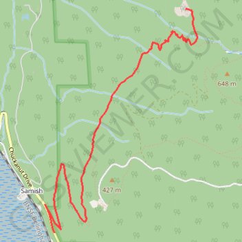
Oyster Dome via Chuckanut Trail and Samish Bay Connector in Blanchard State Forest
The hike to Oyster Dome is a rewarding journey through the serene Blanchard State Forest. The route begins with steady switchbacks, winding through a lush canopy of Douglas fir, maple, and cedar, offering moments of tranquility punctuated by expansive views over Samish Bay. Upon reaching the rocky summit, hikers are treated to sweeping vistas of the San Juan Islands, distant mountains, and occasionally, sightings of bald eagles, making the effort well worth it. #Hiking #Mountain #Overlook #Forest #Nature
- Distance: 6.2 mi
- Elevation gain: 1,988 ft
- Maximum elevation: 1,982 ft
- Elevation loss: 2,034 ft
- Minimum elevation: 148 ft
Interactive trail map
Make a donation
Gear up for your next adventure:
As an Amazon Associate, this site earns from qualifying purchases at no extra cost to you.
Trail profile
- Distance: 6.2 mi
- Elevation gain: 1,988 ft
- Maximum elevation: 1,982 ft
- Elevation loss: 2,034 ft
- Minimum elevation: 148 ft
Make a donation
Gear up for your next adventure:
As an Amazon Associate, this site earns from qualifying purchases at no extra cost to you.
About this trail
Name: Oyster Dome via Chuckanut Trail and Samish Bay Connector in Blanchard State Forest trail, distance, elevation, map, profile, GPS track
Start: Chuckanut Drive, Samish, Skagit County, Washington, United States (48.60969 -122.43401)
End: 2669, Chuckanut Drive, Samish, Skagit County, Washington, 98232, United States (48.60720 -122.43266)
Coordinates: 48.60720 -122.43401 48.62693 -122.41365
Topography: Skagit County topographic map, elevation, terrain
Make a donation
Gear up for your next adventure:
As an Amazon Associate, this site earns from qualifying purchases at no extra cost to you.
Other hiking, mountain biking, running and outdoor activity trails
Click on a trail to view its statistics, map and profile.
Oyster Dome Trail in Blanchard State Forest
United States > Washington > Skagit County > Samish
The Oyster Dome Trail, accessed via Chuckanut Drive and the Samish Bay Connector, offers hikers a rewarding journey through Blanchard State Forest. The path meanders through lush forests of alder, cedar, and Douglas fir, with occasional views of the Salish Sea and the Olympic Peninsula. The trail culminates at…
Distance: 6.7 mi • Elevation gain: 2,014 ft • Maximum elevation: 1,991 ft
Oyster Dome Trail via Samish Bay Connector in Blanchard State Forest
United States > Washington > Skagit County > Samish
The Oyster Dome Trail offers a scenic and moderately challenging hike with rewarding views throughout. Starting from Samish Overlook, the route ascends through lush vegetation, including towering Douglas firs and cedar trees, leading hikers past impressive remnants of historical logging. Upon reaching the…
Distance: 4.3 mi • Elevation gain: 1,214 ft • Maximum elevation: 1,991 ft
Oyster Dome loop hike via Lily Lake from Samish Overlook
United States > Washington > Skagit County > Samish
Distance: 6.6 mi • Elevation gain: 1,411 ft • Maximum elevation: 2,077 ft