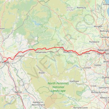
Carlisle Running
Rat race the wall 2024
- Distance: 69.8 mi
- Elevation gain: 4,403 ft
- Maximum elevation: 1,089 ft
- Elevation loss: 4,462 ft
- Minimum elevation: 3 ft
- Moving time: 14 h 51 m
- Moving speed: 4.7 mph
- Maximum speed: 10.7 mph
- Total time: 16 h 3 m
- Global speed: 4.3 mph
Interactive trail map
Trail profile
- Distance: 69.8 mi
- Elevation gain: 4,403 ft
- Maximum elevation: 1,089 ft
- Elevation loss: 4,462 ft
- Minimum elevation: 3 ft
- Moving time: 14 h 51 m
- Moving speed: 4.7 mph
- Maximum speed: 10.7 mph
- Total time: 16 h 3 m
- Global speed: 4.3 mph
About this trail
Name: Carlisle Running trail, distance, elevation, map, profile, GPS track
Coordinates: 54.89631 -2.94178 55.00835 -1.59914
Other hiking, mountain biking, running and outdoor activity trails
Click on a trail to view its statistics, map and profile.
Carlisle Walk
United Kingdom > England > Cumberland > Carlisle
Walk through Carlisle from Carlisle Castle to University of Cumbria via Weaver's Bank, Mayor's Drive, Bitts Park, Swifts Bank, River Eden, Former Swifts Golf Course and Rickerby Park. #Walking #Hiking #Nature #Park #Forest #River #Castle
Distance: 2.6 mi • Elevation gain: 75 ft • Maximum elevation: 92 ft
Track and Path from Stagshaw Path up to Cold Fell and back round Stagshaw
United Kingdom > England > Cumberland > Hallbankgate
Distance: 6.7 mi • Elevation gain: 1,430 ft • Maximum elevation: 2,034 ft
Leamington and Walbottle circular
United Kingdom > England > Tyne and Wear > Newcastle upon Tyne > Blucher
Distance: 2.1 mi • Elevation gain: 236 ft • Maximum elevation: 295 ft