Leamington and Walbottle circular
- Distance: 2.1 mi
- Elevation gain: 236 ft
- Maximum elevation: 295 ft
- Elevation loss: 236 ft
- Minimum elevation: 112 ft
- Moving time: 47 m 49 s
- Moving speed: 2.6 mph
- Maximum speed: 4.2 mph
- Total time: 51 m 35 s
- Global speed: 2.4 mph
Interactive trail map
Trail profile
- Distance: 2.1 mi
- Elevation gain: 236 ft
- Maximum elevation: 295 ft
- Elevation loss: 236 ft
- Minimum elevation: 112 ft
- Moving time: 47 m 49 s
- Moving speed: 2.6 mph
- Maximum speed: 4.2 mph
- Total time: 51 m 35 s
- Global speed: 2.4 mph
About this trail
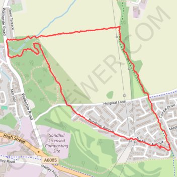
Name: Leamington and Walbottle circular trail, distance, elevation, map, profile, GPS track
Coordinates: 54.98082 -1.73708 54.98778 -1.72101
Other hiking, mountain biking, running and outdoor activity trails
Click on a trail to view its statistics, map and profile.
Carlisle Running
United Kingdom > England > Cumberland > Carlisle
Rat race the wall 2024
Distance: 69.8 mi • Elevation gain: 4,403 ft • Maximum elevation: 1,089 ft