Make a donation
Gear up for your next adventure:
As an Amazon Associate, this site earns from qualifying purchases at no extra cost to you.
Divided from: Zeopoxa Cycling
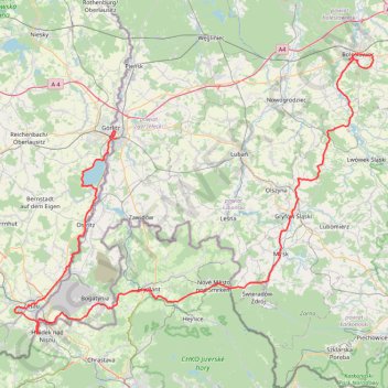
- Distance: 106.9 mi
- Elevation gain: 5,876 ft
- Maximum elevation: 1,798 ft
- Elevation loss: 5,925 ft
- Minimum elevation: 531 ft
Interactive trail map
Make a donation
Gear up for your next adventure:
As an Amazon Associate, this site earns from qualifying purchases at no extra cost to you.
Trail profile
- Distance: 106.9 mi
- Elevation gain: 5,876 ft
- Maximum elevation: 1,798 ft
- Elevation loss: 5,925 ft
- Minimum elevation: 531 ft
Make a donation
Gear up for your next adventure:
As an Amazon Associate, this site earns from qualifying purchases at no extra cost to you.
About this trail
Name: Divided from: Zeopoxa Cycling trail, distance, elevation, map, profile, GPS track
Coordinates: 50.85421 14.76869 51.26298 15.60175
Make a donation
Gear up for your next adventure:
As an Amazon Associate, this site earns from qualifying purchases at no extra cost to you.
Other hiking, mountain biking, running and outdoor activity trails
Click on a trail to view its statistics, map and profile.
Görlitz - Alpen
Germany > Saxony > Görlitz > Görlitz
Distance: 465.7 mi • Elevation gain: 16,929 ft • Maximum elevation: 1,463 ft
Görlitz - Alpen
Germany > Saxony > Görlitz > Görlitz
Distance: 465.7 mi • Elevation gain: 16,929 ft • Maximum elevation: 1,463 ft