Make a donation
Gear up for your next adventure:
As an Amazon Associate, this site earns from qualifying purchases at no extra cost to you.
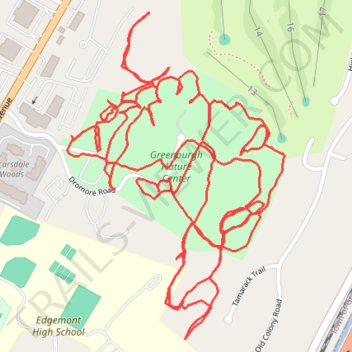
Greenburgh Nature Center Trails
- Distance: 4.0 mi
- Elevation gain: 220 ft
- Maximum elevation: 364 ft
- Elevation loss: 223 ft
- Minimum elevation: 305 ft
- Moving time: 1 h 6 m
- Moving speed: 3.6 mph
- Maximum speed: 5.7 mph
- Total time: 1 h 7 m
- Global speed: 3.6 mph
Interactive trail map
Make a donation
Gear up for your next adventure:
As an Amazon Associate, this site earns from qualifying purchases at no extra cost to you.
Trail profile
- Distance: 4.0 mi
- Elevation gain: 220 ft
- Maximum elevation: 364 ft
- Elevation loss: 223 ft
- Minimum elevation: 305 ft
- Moving time: 1 h 6 m
- Moving speed: 3.6 mph
- Maximum speed: 5.7 mph
- Total time: 1 h 7 m
- Global speed: 3.6 mph
Make a donation
Gear up for your next adventure:
As an Amazon Associate, this site earns from qualifying purchases at no extra cost to you.
About this trail
Name: Greenburgh Nature Center Trails trail, distance, elevation, map, profile, GPS track
Coordinates: 41.00136 -73.80970 41.00776 -73.80402
Topography: Westchester County topographic map, elevation, terrain
Make a donation
Gear up for your next adventure:
As an Amazon Associate, this site earns from qualifying purchases at no extra cost to you.
Other hiking, mountain biking, running and outdoor activity trails
Click on a trail to view its statistics, map and profile.
Bronx River Pathway
United States > New York > Westchester County > City of Yonkers
Distance: 13.8 mi • Elevation gain: 505 ft • Maximum elevation: 184 ft