Maxwell Falls Loop via Maxwell Falls Bluffs Trail in Arapaho National Forest
The Maxwell Falls Loop via the Maxwell Falls Bluffs Trail in Arapaho National Forest offers a scenic hike through dense pine forests and alongside Maxwell Creek, culminating in views of the cascading falls. The trail provides a balance of tranquil woodland paths and rugged terrain, with rocky sections that add a bit of adventure. Hikers are rewarded with a serene waterfall and sweeping views from elevated bluffs, making it a well-rounded trek that highlights Colorado’s natural beauty. #Hiking #Loop #Waterfall #Forest #Nature
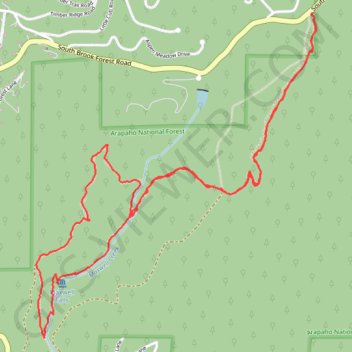
- Distance: 4.8 mi
- Elevation gain: 1,073 ft
- Maximum elevation: 8,419 ft
- Elevation loss: 1,076 ft
- Minimum elevation: 7,769 ft
- Moving time: 2 h 18 m
- Moving speed: 2.1 mph
- Maximum speed: 3.9 mph
- Total time: 3 h 9 m
- Global speed: 1.5 mph
Interactive trail map
Trail profile
- Distance: 4.8 mi
- Elevation gain: 1,073 ft
- Maximum elevation: 8,419 ft
- Elevation loss: 1,076 ft
- Minimum elevation: 7,769 ft
- Moving time: 2 h 18 m
- Moving speed: 2.1 mph
- Maximum speed: 3.9 mph
- Total time: 3 h 9 m
- Global speed: 1.5 mph
About this trail
Name: Maxwell Falls Loop via Maxwell Falls Bluffs Trail in Arapaho National Forest trail, distance, elevation, map, profile, GPS track
Coordinates: 39.56598 -105.37914 39.58254 -105.36065
Topography: Jefferson County topographic map, elevation, terrain
Other hiking, mountain biking, running and outdoor activity trails
Click on a trail to view its statistics, map and profile.