Thank you for supporting this site ❤️
Make a donation
Make a donation
Gear up for your next adventure:
As an Amazon Associate, this site earns from qualifying purchases at no extra cost to you.
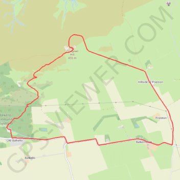
Craigowl Hill Loop
Loop run / hike from Balkello Community Woodland to Craigowl Hill. #Running #Hiking #Loop #Nature #Forest #Countryside
- Distance: 5.8 mi
- Elevation gain: 1,017 ft
- Maximum elevation: 1,480 ft
- Elevation loss: 1,017 ft
- Minimum elevation: 502 ft
- Moving time: 1 h 2 m
- Moving speed: 5.5 mph
- Maximum speed: 17.4 mph
- Total time: 1 h 19 m
- Global speed: 4.3 mph
Interactive trail map
Thank you for supporting this site ❤️
Make a donation
Make a donation
Gear up for your next adventure:
As an Amazon Associate, this site earns from qualifying purchases at no extra cost to you.
Trail profile
- Distance: 5.8 mi
- Elevation gain: 1,017 ft
- Maximum elevation: 1,480 ft
- Elevation loss: 1,017 ft
- Minimum elevation: 502 ft
- Moving time: 1 h 2 m
- Moving speed: 5.5 mph
- Maximum speed: 17.4 mph
- Total time: 1 h 19 m
- Global speed: 4.3 mph
Thank you for supporting this site ❤️
Make a donation
Make a donation
Gear up for your next adventure:
As an Amazon Associate, this site earns from qualifying purchases at no extra cost to you.
About this trail
Name: Craigowl Hill Loop trail, distance, elevation, map, profile, GPS track
Coordinates: 56.53164 -3.03471 56.54998 -2.98456
Thank you for supporting this site ❤️
Make a donation
Make a donation
Gear up for your next adventure:
As an Amazon Associate, this site earns from qualifying purchases at no extra cost to you.