Thank you for supporting this site ❤️
Make a donation
Make a donation
Gear up for your next adventure:
As an Amazon Associate, this site earns from qualifying purchases at no extra cost to you.
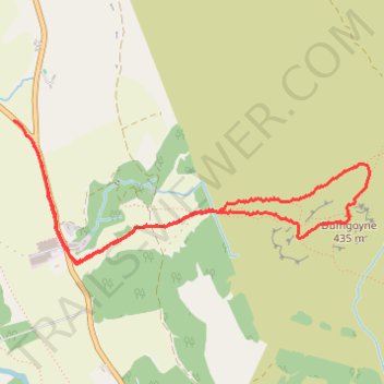
Dumgoyne Loop Trail
- Distance: 3.2 mi
- Elevation gain: 1,293 ft
- Maximum elevation: 1,342 ft
- Elevation loss: 1,270 ft
- Minimum elevation: 85 ft
- Moving time: 2 h 6 m
- Moving speed: 1.5 mph
- Maximum speed: 5.8 mph
- Total time: 2 h 56 m
- Global speed: 1.1 mph
Interactive trail map
Thank you for supporting this site ❤️
Make a donation
Make a donation
Gear up for your next adventure:
As an Amazon Associate, this site earns from qualifying purchases at no extra cost to you.
Trail profile
- Distance: 3.2 mi
- Elevation gain: 1,293 ft
- Maximum elevation: 1,342 ft
- Elevation loss: 1,270 ft
- Minimum elevation: 85 ft
- Moving time: 2 h 6 m
- Moving speed: 1.5 mph
- Maximum speed: 5.8 mph
- Total time: 2 h 56 m
- Global speed: 1.1 mph
Thank you for supporting this site ❤️
Make a donation
Make a donation
Gear up for your next adventure:
As an Amazon Associate, this site earns from qualifying purchases at no extra cost to you.
About this trail
Name: Dumgoyne Loop Trail trail, distance, elevation, map, profile, GPS track
Start: A81, Dumgoyne, Stirling, Scotland, G63 9LD, United Kingdom (56.01976 -4.36790)
End: A81, Dumgoyne, Stirling, Scotland, G63 9LD, United Kingdom (56.01875 -4.36646)
Coordinates: 56.01331 -4.36790 56.01976 -4.33954
Thank you for supporting this site ❤️
Make a donation
Make a donation
Gear up for your next adventure:
As an Amazon Associate, this site earns from qualifying purchases at no extra cost to you.
Other hiking, mountain biking, running and outdoor activity trails
Click on a trail to view its statistics, map and profile.