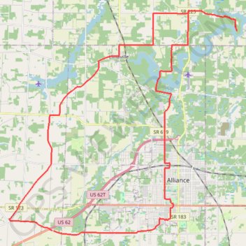
Berlin Lake Wildlife Area Loop
MTB loop to Berlin Lake Wildlife Area via Harrisburg, Limaville, Mahoning River, Deer Creek Reservoir, Bolton, Alliance and Mount Union. #MTB #Loop #Nature #Countryside #Lake #River #Forest #City
- Distance: 33.8 mi
- Elevation gain: 1,010 ft
- Maximum elevation: 1,289 ft
- Elevation loss: 1,014 ft
- Minimum elevation: 1,027 ft
- Moving time: 1 h 58 m
- Moving speed: 17.1 mph
- Maximum speed: 25.8 mph
- Total time: 2 h 1 m
- Global speed: 16.7 mph
Interactive trail map
Trail profile
- Distance: 33.8 mi
- Elevation gain: 1,010 ft
- Maximum elevation: 1,289 ft
- Elevation loss: 1,014 ft
- Minimum elevation: 1,027 ft
- Moving time: 1 h 58 m
- Moving speed: 17.1 mph
- Maximum speed: 25.8 mph
- Total time: 2 h 1 m
- Global speed: 16.7 mph
About this trail
Name: Berlin Lake Wildlife Area Loop trail, distance, elevation, map, profile, GPS track
Coordinates: 40.88562 -81.22656 41.00655 -81.06400
Topography: Stark County topographic map, elevation, terrain
Other hiking, mountain biking, running and outdoor activity trails
Click on a trail to view its statistics, map and profile.
Trails at Walborn Reservoir, as traversed on MTB
United States > Ohio > Stark County
Getting dirty at Walborn
Distance: 12.2 mi • Elevation gain: 591 ft • Maximum elevation: 1,168 ft