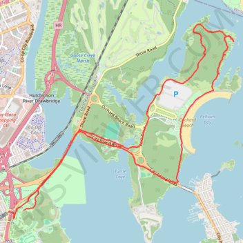
Pelham Bay Park Loop
Loop hike through Pelham Bay Park via Hutchinson River, Orchard Beach and Hunter Island. #Hiking #Loop #Nature #Forest #Sea #Atlantic #Ocean #Beach #Island #River #Park
- Distance: 8.2 mi
- Elevation gain: 341 ft
- Maximum elevation: 69 ft
- Elevation loss: 331 ft
- Minimum elevation: -7 ft
- Moving time: 2 h 58 m
- Moving speed: 2.7 mph
- Maximum speed: 4.7 mph
- Total time: 3 h 38 m
- Global speed: 2.2 mph
Interactive trail map
Trail profile
- Distance: 8.2 mi
- Elevation gain: 341 ft
- Maximum elevation: 69 ft
- Elevation loss: 331 ft
- Minimum elevation: -7 ft
- Moving time: 2 h 58 m
- Moving speed: 2.7 mph
- Maximum speed: 4.7 mph
- Total time: 3 h 38 m
- Global speed: 2.2 mph
About this trail
Name: Pelham Bay Park Loop trail, distance, elevation, map, profile, GPS track
Coordinates: 40.85210 -73.82685 40.87968 -73.78461
Topography: New York topographic map, elevation, terrain
Other hiking, mountain biking, running and outdoor activity trails
Click on a trail to view its statistics, map and profile.