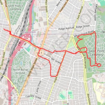
Swan Point Cemetery
- Distance: 5.8 mi
- Elevation gain: 292 ft
- Maximum elevation: 151 ft
- Elevation loss: 292 ft
- Minimum elevation: 23 ft
- Moving time: 50 m 5 s
- Moving speed: 6.9 mph
- Maximum speed: 9.2 mph
- Total time: 50 m 5 s
- Global speed: 6.9 mph
Interactive trail map
Trail profile
- Distance: 5.8 mi
- Elevation gain: 292 ft
- Maximum elevation: 151 ft
- Elevation loss: 292 ft
- Minimum elevation: 23 ft
- Moving time: 50 m 5 s
- Moving speed: 6.9 mph
- Maximum speed: 9.2 mph
- Total time: 50 m 5 s
- Global speed: 6.9 mph
About this trail
Name: Swan Point Cemetery trail, distance, elevation, map, profile, GPS track
Coordinates: 41.84684 -71.41289 41.85820 -71.38191
Topography: Providence topographic map, elevation, terrain
Other hiking, mountain biking, running and outdoor activity trails
Click on a trail to view its statistics, map and profile.
Cambridge - Providence Express
United States > Massachusetts > Middlesex County > Cambridge
Alewife -> Providence
Distance: 63.2 mi • Elevation gain: 3,153 ft • Maximum elevation: 351 ft
Dedham-Providence-Dedham
United States > Massachusetts > Norfolk County > Dedham
Distance: 126.0 mi • Elevation gain: 5,942 ft • Maximum elevation: 548 ft