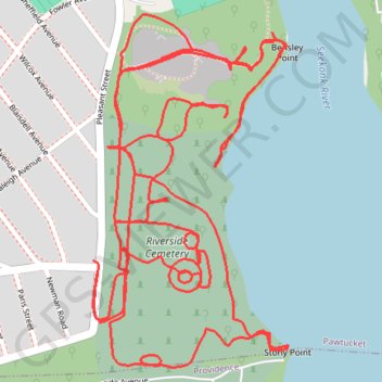
Riverside Cemetery Loop
Loop hike / run in the Riverside Cemetery via Bensley Point and Stony Point along the Skeleton River. #Hiking #Running #Loop #Nature #Forest #River
- Distance: 4.1 mi
- Elevation gain: 371 ft
- Maximum elevation: 102 ft
- Elevation loss: 367 ft
- Minimum elevation: -16 ft
- Moving time: 42 m 55 s
- Moving speed: 5.7 mph
- Maximum speed: 9.3 mph
- Total time: 50 m 41 s
- Global speed: 4.8 mph
Interactive trail map
Trail profile
- Distance: 4.1 mi
- Elevation gain: 371 ft
- Maximum elevation: 102 ft
- Elevation loss: 367 ft
- Minimum elevation: -16 ft
- Moving time: 42 m 55 s
- Moving speed: 5.7 mph
- Maximum speed: 9.3 mph
- Total time: 50 m 41 s
- Global speed: 4.8 mph
About this trail
Name: Riverside Cemetery Loop trail, distance, elevation, map, profile, GPS track
Coordinates: 41.85718 -71.38393 41.86358 -71.37918
Topography: Pawtucket topographic map, elevation, terrain
Other hiking, mountain biking, running and outdoor activity trails
Click on a trail to view its statistics, map and profile.
Cambridge - Providence Express
United States > Massachusetts > Middlesex County > Cambridge
Alewife -> Providence
Distance: 63.2 mi • Elevation gain: 3,153 ft • Maximum elevation: 351 ft
Dedham-Providence-Dedham
United States > Massachusetts > Norfolk County > Dedham
Distance: 126.0 mi • Elevation gain: 5,942 ft • Maximum elevation: 548 ft
Swan Point Cemetery
United States > Rhode Island > Providence County > Providence
Distance: 5.8 mi • Elevation gain: 292 ft • Maximum elevation: 151 ft