Hamilton Mountain Loop Trail via Hardy Falls, Rodney Falls and Hardy Creek
The Hamilton Mountain Loop Trail in Beacon Rock State Park offers a rewarding experience for hikers seeking both natural beauty and a physical challenge. Along the way, hikers will encounter cascading waterfalls like Hardy Falls and Rodney Falls, each framed by lush greenery. The trail also provides panoramic views of the Columbia River Gorge and surrounding peaks, particularly from the summit of Hamilton Mountain, where the expansive landscape reveals Table Mountain and the Bonneville Dam. #Hiking #Mountain #Forest #Nature #Loop #Waterfall #Overlook
- Distance: 7.4 mi
- Elevation gain: 2,592 ft
- Maximum elevation: 2,313 ft
- Elevation loss: 2,595 ft
- Minimum elevation: 449 ft
- Moving time: 2 h 39 m
- Moving speed: 2.8 mph
- Maximum speed: 12.3 mph
- Total time: 2 h 50 m
- Global speed: 2.6 mph
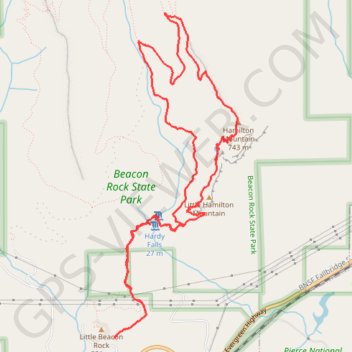
Interactive trail map
Trail profile
About this trail
Name: Hamilton Mountain Loop Trail via Hardy Falls, Rodney Falls and Hardy Creek trail, distance, elevation, map, profile, GPS track
Start: Hamilton Mountain Trail, Skamania County, Washington, 97014, United States (45.63296 -122.02012)
End: Hamilton Mountain Trail, Skamania County, Washington, 97014, United States (45.63293 -122.02012)
Coordinates: 45.63293 -122.02012 45.66010 -122.00529
Topography: Skamania County topographic map, elevation, terrain
Other hiking, mountain biking, running and outdoor activity trails
Click on a trail to view its statistics, map and profile.
Hamilton Mountain Loop Trail via Little Hamilton Mountain and Hamilton Saddle
United States > Washington > Skamania County
The Hamilton Mountain Loop Trail in Beacon Rock State Park offers a dynamic hiking experience with varied landscapes. Hikers can expect to pass through lush forests, with an abundance of wildflowers in spring and colorful leaves in fall, before reaching impressive views of the Columbia River Gorge and…
Distance: 7.0 mi • Elevation gain: 2,431 ft • Maximum elevation: 2,313 ft
Northern part of the Pacific Crest Trail (PCT)
United States > Oregon > Klamath County
Hike on the Pacific Crest National Scenic Trail from Crater Lake to Canada Border through Oregon and Washington along the Sierra Nevada and Cascade mountain ranges. #Hiking #Mountain #SierraNevada #Cascade #Nature #Forest #Park #PCT
Distance: 744.6 mi • Elevation gain: 145,367 ft • Maximum elevation: 7,569 ft
Expedition to Sedum Ridge
United States > Oregon > Multnomah County > Portland
Distance: 133.4 mi • Elevation gain: 16,709 ft • Maximum elevation: 3,835 ft