Make a donation
Gear up for your next adventure:
As an Amazon Associate, this site earns from qualifying purchases at no extra cost to you.
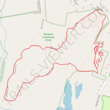
Loop walk at Plimpton Forest in Sturbridge
- Distance: 3.3 mi
- Elevation gain: 194 ft
- Maximum elevation: 797 ft
- Elevation loss: 194 ft
- Minimum elevation: 630 ft
- Moving time: 1 h 28 m
- Moving speed: 2.2 mph
- Maximum speed: 4.9 mph
- Total time: 1 h 36 m
- Global speed: 2.0 mph
Interactive trail map
Make a donation
Gear up for your next adventure:
As an Amazon Associate, this site earns from qualifying purchases at no extra cost to you.
Trail profile
- Distance: 3.3 mi
- Elevation gain: 194 ft
- Maximum elevation: 797 ft
- Elevation loss: 194 ft
- Minimum elevation: 630 ft
- Moving time: 1 h 28 m
- Moving speed: 2.2 mph
- Maximum speed: 4.9 mph
- Total time: 1 h 36 m
- Global speed: 2.0 mph
Make a donation
Gear up for your next adventure:
As an Amazon Associate, this site earns from qualifying purchases at no extra cost to you.
About this trail
Name: Loop walk at Plimpton Forest in Sturbridge trail, distance, elevation, map, profile, GPS track
Start: Holden Trail, Sturbridge, Worcester County, Massachusetts, 01566, United States (42.14823 -72.07897)
End: Holden Trail, Sturbridge, Worcester County, Massachusetts, 01566, United States (42.14813 -72.07904)
Coordinates: 42.14544 -72.09165 42.15462 -72.07792
Topography: Worcester County topographic map, elevation, terrain
Make a donation
Gear up for your next adventure:
As an Amazon Associate, this site earns from qualifying purchases at no extra cost to you.
Other hiking, mountain biking, running and outdoor activity trails
Click on a trail to view its statistics, map and profile.
Short walk on start of Holden Trail at Plimpton Forest in Sturbridge
United States > Massachusetts > Worcester County > Sturbridge
Distance: 0.8 mi • Elevation gain: 98 ft • Maximum elevation: 702 ft