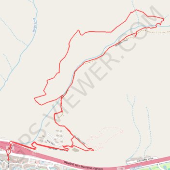
Spraddle Creek Loop
Loop hike from Vail along Spraddle Creek via Spraddle Creek Trail in the White River National Forest. #Hiking #Loop #River #Mountain #Nature #Forest
- Distance: 7.1 mi
- Elevation gain: 1,873 ft
- Maximum elevation: 9,918 ft
- Elevation loss: 1,870 ft
- Minimum elevation: 8,179 ft
- Moving time: 2 h 48 m
- Moving speed: 2.5 mph
- Maximum speed: 4.0 mph
- Total time: 3 h 12 m
- Global speed: 2.2 mph
Interactive trail map
Trail profile
- Distance: 7.1 mi
- Elevation gain: 1,873 ft
- Maximum elevation: 9,918 ft
- Elevation loss: 1,870 ft
- Minimum elevation: 8,179 ft
- Moving time: 2 h 48 m
- Moving speed: 2.5 mph
- Maximum speed: 4.0 mph
- Total time: 3 h 12 m
- Global speed: 2.2 mph
About this trail
Name: Spraddle Creek Loop trail, distance, elevation, map, profile, GPS track
Start: 9, Vail Road, Vail, Eagle County, Colorado, 81657, United States (39.64248 -106.37817)
Coordinates: 39.64248 -106.37857 39.66233 -106.35167
Topography: Eagle County topographic map, elevation, terrain
Other hiking, mountain biking, running and outdoor activity trails
Click on a trail to view its statistics, map and profile.
Vail to Lost Lake
United States > Colorado > Eagle County > Vail
Morning Ride lost, lake, vail, lostlake, lake, trail, foresttrail, forest, road, trail, hike, bike
Distance: 12.8 mi • Elevation gain: 2,799 ft • Maximum elevation: 10,144 ft