Logan Canyon Loop
Loop hike along Logan River from Ray Hugie Hydro Park via River Trail, Highline Trail and Bonneville Shoreline Trail. #Hiking #Loop #Nature #River #Canyon #Mountain #Forest #Park
- Distance: 3.1 mi
- Elevation gain: 486 ft
- Maximum elevation: 4,918 ft
- Elevation loss: 472 ft
- Minimum elevation: 4,692 ft
- Moving time: 58 m 59 s
- Moving speed: 3.2 mph
- Maximum speed: 4.5 mph
- Total time: 1 h 2 m
- Global speed: 3.0 mph
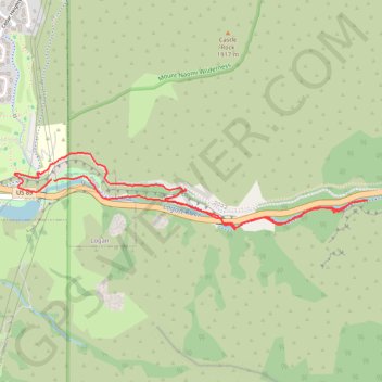
Interactive trail map
Trail profile
- Distance: 3.1 mi
- Elevation gain: 486 ft
- Maximum elevation: 4,918 ft
- Elevation loss: 472 ft
- Minimum elevation: 4,692 ft
- Moving time: 58 m 59 s
- Moving speed: 3.2 mph
- Maximum speed: 4.5 mph
- Total time: 1 h 2 m
- Global speed: 3.0 mph
About this trail
Name: Logan Canyon Loop trail, distance, elevation, map, profile, GPS track
Start: US 89, Hillcrest Neighborhood, Logan, Cache County, Utah, 84322, United States (41.74372 -111.78578)
Coordinates: 41.74121 -111.78853 41.74514 -111.76416
Topography: Logan topographic map, elevation, terrain
Other hiking, mountain biking, running and outdoor activity trails
Click on a trail to view its statistics, map and profile.
Highline Trail and Logan Canyon Gateway Trail loop
United States > Utah > Cache County > Logan
Distance: 3.6 mi • Elevation gain: 656 ft • Maximum elevation: 5,052 ft
Logan River Trail
United States > Utah > Cache County
Distance: 5.7 mi • Elevation gain: 492 ft • Maximum elevation: 5,082 ft
Bonneville Shoreline Trail
United States > Utah > Cache County > Logan
cycling, mtb
Distance: 5.8 mi • Elevation gain: 653 ft • Maximum elevation: 5,098 ft
2025-05-21_08-53_Wed
United States > Utah > Cache County > Logan
Canal Road and Canyon Road Loop Walk
Distance: 2.8 mi • Elevation gain: 256 ft • Maximum elevation: 4,816 ft