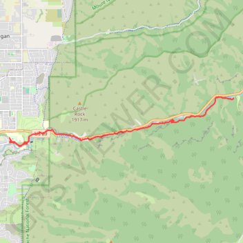
Logan River Trail
- Distance: 5.7 mi
- Elevation gain: 492 ft
- Maximum elevation: 5,082 ft
- Elevation loss: 876 ft
- Minimum elevation: 4,629 ft
Interactive trail map
Trail profile
- Distance: 5.7 mi
- Elevation gain: 492 ft
- Maximum elevation: 5,082 ft
- Elevation loss: 876 ft
- Minimum elevation: 4,629 ft
About this trail
Name: Logan River Trail trail, distance, elevation, map, profile, GPS track
Coordinates: 41.73971 -111.79926 41.75291 -111.71825
Topography: Cache County topographic map, elevation, terrain
Other hiking, mountain biking, running and outdoor activity trails
Click on a trail to view its statistics, map and profile.
Highline Trail and Logan Canyon Gateway Trail loop
United States > Utah > Cache County > Logan
Distance: 3.6 mi • Elevation gain: 656 ft • Maximum elevation: 5,052 ft
Bonneville Shoreline Trail
United States > Utah > Cache County > Logan
cycling, mtb
Distance: 5.8 mi • Elevation gain: 653 ft • Maximum elevation: 5,098 ft
2025-05-21_08-53_Wed
United States > Utah > Cache County > Logan
Canal Road and Canyon Road Loop Walk
Distance: 2.8 mi • Elevation gain: 256 ft • Maximum elevation: 4,816 ft