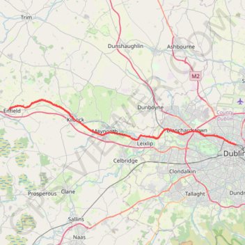
Thank you for supporting this site ❤️
Make a donation
Make a donation
Gear up for your next adventure:
As an Amazon Associate, this site earns from qualifying purchases at no extra cost to you.
Royal canal way
#Bike
- Distance: 27.2 mi
- Elevation gain: 322 ft
- Maximum elevation: 266 ft
- Elevation loss: 535 ft
- Minimum elevation: 33 ft
Interactive trail map
Thank you for supporting this site ❤️
Make a donation
Make a donation
Gear up for your next adventure:
As an Amazon Associate, this site earns from qualifying purchases at no extra cost to you.
Trail profile
- Distance: 27.2 mi
- Elevation gain: 322 ft
- Maximum elevation: 266 ft
- Elevation loss: 535 ft
- Minimum elevation: 33 ft
Thank you for supporting this site ❤️
Make a donation
Make a donation
Gear up for your next adventure:
As an Amazon Associate, this site earns from qualifying purchases at no extra cost to you.
About this trail
Name: Royal canal way trail, distance, elevation, map, profile, GPS track
Coordinates: 53.36160 -6.83618 53.42977 -6.25845
Thank you for supporting this site ❤️
Make a donation
Make a donation
Gear up for your next adventure:
As an Amazon Associate, this site earns from qualifying purchases at no extra cost to you.
Other hiking, mountain biking, running and outdoor activity trails
Click on a trail to view its statistics, map and profile.