Make a donation
Gear up for your next adventure:
As an Amazon Associate, this site earns from qualifying purchases at no extra cost to you.
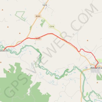
Alexandra - Cathkin - Molesworth
#Bike
- Distance: 12.2 mi
- Elevation gain: 646 ft
- Maximum elevation: 945 ft
- Elevation loss: 781 ft
- Minimum elevation: 554 ft
Interactive trail map
Make a donation
Gear up for your next adventure:
As an Amazon Associate, this site earns from qualifying purchases at no extra cost to you.
Trail profile
- Distance: 12.2 mi
- Elevation gain: 646 ft
- Maximum elevation: 945 ft
- Elevation loss: 781 ft
- Minimum elevation: 554 ft
Make a donation
Gear up for your next adventure:
As an Amazon Associate, this site earns from qualifying purchases at no extra cost to you.
About this trail
Name: Alexandra - Cathkin - Molesworth trail, distance, elevation, map, profile, GPS track
Start: 108, Grant Street, Alexandra, Shire of Murrindindi, Victoria, 3714, Australia (-37.19340 145.71034)
Coordinates: -37.19340 145.54191 -37.14281 145.71437
Make a donation
Gear up for your next adventure:
As an Amazon Associate, this site earns from qualifying purchases at no extra cost to you.
Other hiking, mountain biking, running and outdoor activity trails
Click on a trail to view its statistics, map and profile.
Tallarook - Eildon - Hurstbridge
Australia > Victoria > Tallarook
#Bike
Distance: 173.2 mi • Elevation gain: 16,066 ft • Maximum elevation: 2,848 ft
Molesworth - Yea
Australia > Victoria > Molesworth
Great Victorian Rail Trail. #Bike
Distance: 11.0 mi • Elevation gain: 620 ft • Maximum elevation: 994 ft
Great Victorian Rail Trail Alexandra to Yarck
Australia > Victoria > Alexandra
Distance: 26.8 mi • Elevation gain: 1,414 ft • Maximum elevation: 945 ft