Make a donation
Gear up for your next adventure:
As an Amazon Associate, this site earns from qualifying purchases at no extra cost to you.
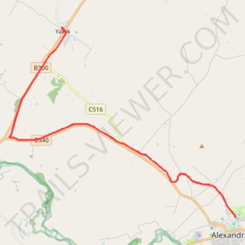
Great Victorian Rail Trail Alexandra to Yarck
- Distance: 26.8 mi
- Elevation gain: 1,414 ft
- Maximum elevation: 945 ft
- Elevation loss: 1,414 ft
- Minimum elevation: 584 ft
- Moving time: 2 h 32 m
- Moving speed: 10.5 mph
- Maximum speed: 19.2 mph
- Total time: 4 h 47 m
- Global speed: 5.6 mph
Interactive trail map
Make a donation
Gear up for your next adventure:
As an Amazon Associate, this site earns from qualifying purchases at no extra cost to you.
Trail profile
- Distance: 26.8 mi
- Elevation gain: 1,414 ft
- Maximum elevation: 945 ft
- Elevation loss: 1,414 ft
- Minimum elevation: 584 ft
- Moving time: 2 h 32 m
- Moving speed: 10.5 mph
- Maximum speed: 19.2 mph
- Total time: 4 h 47 m
- Global speed: 5.6 mph
Make a donation
Gear up for your next adventure:
As an Amazon Associate, this site earns from qualifying purchases at no extra cost to you.
About this trail
Name: Great Victorian Rail Trail Alexandra to Yarck trail, distance, elevation, map, profile, GPS track
End: Station Street, Alexandra, Shire of Murrindindi, Victoria, 3714, Australia (-37.18460 145.71375)
Coordinates: -37.18478 145.58646 -37.09942 145.71404
Make a donation
Gear up for your next adventure:
As an Amazon Associate, this site earns from qualifying purchases at no extra cost to you.
Other hiking, mountain biking, running and outdoor activity trails
Click on a trail to view its statistics, map and profile.
Alexandra - Cathkin - Molesworth
Australia > Victoria > Alexandra
#Bike
Distance: 12.2 mi • Elevation gain: 646 ft • Maximum elevation: 945 ft
Tallarook - Eildon - Hurstbridge
Australia > Victoria > Tallarook
#Bike
Distance: 173.2 mi • Elevation gain: 16,066 ft • Maximum elevation: 2,848 ft