Eden
- Distance: 2.0 mi
- Elevation gain: 367 ft
- Maximum elevation: 988 ft
- Elevation loss: 358 ft
- Minimum elevation: 636 ft
- Moving time: 21 m 16 s
- Moving speed: 5.6 mph
- Maximum speed: 25.0 mph
- Total time: 45 m 37 s
- Global speed: 2.6 mph
Interactive trail map
Trail profile
- Distance: 2.0 mi
- Elevation gain: 367 ft
- Maximum elevation: 988 ft
- Elevation loss: 358 ft
- Minimum elevation: 636 ft
- Moving time: 21 m 16 s
- Moving speed: 5.6 mph
- Maximum speed: 25.0 mph
- Total time: 45 m 37 s
- Global speed: 2.6 mph
About this trail
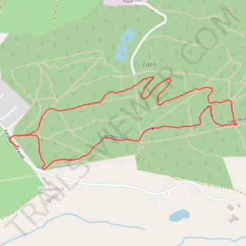
Name: Eden trail, distance, elevation, map, profile, GPS track
Coordinates: -33.97021 18.86508 -33.96640 18.87639
Other hiking, mountain biking, running and outdoor activity trails
Click on a trail to view its statistics, map and profile.
Stellenbosch Ride
South Africa > Western Cape > Cape Winelands District Municipality > Stellenbosch Local Municipality > Stellenbosch
Distance: 31.6 mi • Elevation gain: 4,455 ft • Maximum elevation: 1,152 ft