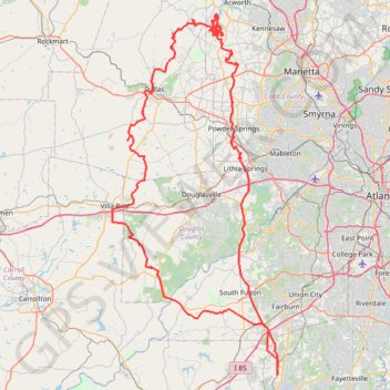
Powder Springs, Allatoona trails, Dallas, Chatt Hills
- Distance: 198.6 mi
- Elevation gain: 12,484 ft
- Maximum elevation: 1,243 ft
- Elevation loss: 12,484 ft
- Minimum elevation: 725 ft
- Moving time: 16 h 36 m
- Moving speed: 12.0 mph
- Maximum speed: 37.9 mph
- Total time: 17 h 59 m
- Global speed: 11.0 mph
Interactive trail map
Trail profile
- Distance: 198.6 mi
- Elevation gain: 12,484 ft
- Maximum elevation: 1,243 ft
- Elevation loss: 12,484 ft
- Minimum elevation: 725 ft
- Moving time: 16 h 36 m
- Moving speed: 12.0 mph
- Maximum speed: 37.9 mph
- Total time: 17 h 59 m
- Global speed: 11.0 mph
About this trail
Name: Powder Springs, Allatoona trails, Dallas, Chatt Hills trail, distance, elevation, map, profile, GPS track
Coordinates: 33.45285 -84.92358 34.04516 -84.59607
Topography: Fayette County topographic map, elevation, terrain
Other hiking, mountain biking, running and outdoor activity trails
Click on a trail to view its statistics, map and profile.
More bike ride on the Silver Comet Trail (and some other side quests)
United States > Georgia > Polk County
Distance: 47.8 mi • Elevation gain: 2,802 ft • Maximum elevation: 1,148 ft
Atlanta, Lilburn, Yellow River Park, Panola, Jonesboro
United States > Georgia > Fayette County > Peachtree City > Stop
Distance: 208.1 mi • Elevation gain: 13,314 ft • Maximum elevation: 1,109 ft
Bike ride down the Silver Comet Trail (and some side quests)
United States > Georgia > Cobb County > Smyrna
Distance: 82.1 mi • Elevation gain: 4,278 ft • Maximum elevation: 1,152 ft
Morrow, Forest Park, Atlanta, Fairburn
United States > Georgia > Fayette County > Peachtree City
Distance: 115.6 mi • Elevation gain: 5,984 ft • Maximum elevation: 1,066 ft
Allatoona Creek Park Wildcat Loop
United States > Georgia > Cobb County
Distance: 2.9 mi • Elevation gain: 279 ft • Maximum elevation: 932 ft
Allatoona Creek Gravel trails
United States > Georgia > Cobb County
Distance: 11.2 mi • Elevation gain: 400 ft • Maximum elevation: 928 ft