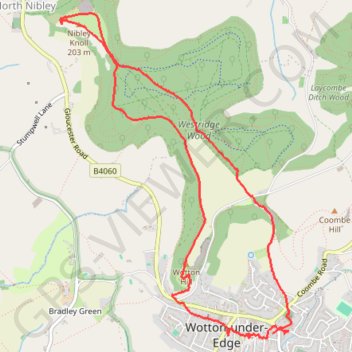
Tyndale Monument loop from Wotton-under-Edge via Westridge Wood, Nibley Knoll and Wotton Hill in the Cotswolds National Landscape
The Tyndale Monument loop offers a delightful hiking experience through the scenic landscapes of the Cotswolds, featuring a mix of woodland trails, rolling hills, and expansive views from both Nibley Knoll and Wotton Hill. Along the way, hikers can explore the historic Tyndale Monument and enjoy the natural beauty of Westridge Wood, making it a refreshing journey for nature lovers and history enthusiasts alike. #Hiking #Loop #Forest #Nature #Cotswolds
- Distance: 5.0 mi
- Elevation gain: 623 ft
- Maximum elevation: 673 ft
- Elevation loss: 646 ft
- Minimum elevation: 226 ft
Interactive trail map
Trail profile
- Distance: 5.0 mi
- Elevation gain: 623 ft
- Maximum elevation: 673 ft
- Elevation loss: 646 ft
- Minimum elevation: 226 ft
About this trail
Name: Tyndale Monument loop from Wotton-under-Edge via Westridge Wood, Nibley Knoll and Wotton Hill in the Cotswolds National Landscape trail, distance, elevation, map, profile, GPS track
Coordinates: 51.63755 -2.37267 51.65931 -2.34772
Other hiking, mountain biking, running and outdoor activity trails
Click on a trail to view its statistics, map and profile.
Loop Walk between Dursley and North Nibley
United Kingdom > England > Gloucestershire > Dursley
Distance: 10.3 mi • Elevation gain: 1,427 ft • Maximum elevation: 712 ft
Wotton-under-Edge Loop
United Kingdom > England > Gloucestershire > Wotton-under-Edge
Distance: 10.0 mi • Elevation gain: 1,266 ft • Maximum elevation: 784 ft
Dean2023-311
United Kingdom > England > Oxfordshire > Oxford
Distance: 192.8 mi • Elevation gain: 11,043 ft • Maximum elevation: 951 ft
Wotton NM
United Kingdom > England > Gloucestershire > Wotton-under-Edge
Distance: 11.7 mi • Elevation gain: 1,237 ft • Maximum elevation: 673 ft