Make a donation
Gear up for your next adventure:
As an Amazon Associate, this site earns from qualifying purchases at no extra cost to you.
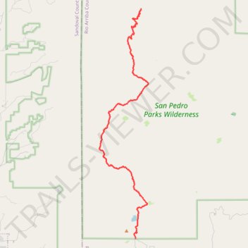
San Pedro Parks Wilderness backpack
- Distance: 14.7 mi
- Elevation gain: 1,837 ft
- Maximum elevation: 10,482 ft
- Elevation loss: 2,267 ft
- Minimum elevation: 8,809 ft
- Moving time: 5 h 34 m
- Moving speed: 2.6 mph
- Maximum speed: 4.3 mph
- Total time: 7 h 21 m
- Global speed: 2.0 mph
Interactive trail map
Make a donation
Gear up for your next adventure:
As an Amazon Associate, this site earns from qualifying purchases at no extra cost to you.
Trail profile
- Distance: 14.7 mi
- Elevation gain: 1,837 ft
- Maximum elevation: 10,482 ft
- Elevation loss: 2,267 ft
- Minimum elevation: 8,809 ft
- Moving time: 5 h 34 m
- Moving speed: 2.6 mph
- Maximum speed: 4.3 mph
- Total time: 7 h 21 m
- Global speed: 2.0 mph
Make a donation
Gear up for your next adventure:
As an Amazon Associate, this site earns from qualifying purchases at no extra cost to you.
About this trail
Name: San Pedro Parks Wilderness backpack trail, distance, elevation, map, profile, GPS track
Start: American Creek Road, Rio Arriba County, New Mexico, United States (36.02810 -106.84768)
End: Rio Arriba County, New Mexico, United States (36.15834 -106.84382)
Coordinates: 36.02810 -106.87333 36.15854 -106.83851
Topography: Rio Arriba County topographic map, elevation, terrain
Make a donation
Gear up for your next adventure:
As an Amazon Associate, this site earns from qualifying purchases at no extra cost to you.
Other hiking, mountain biking, running and outdoor activity trails
Click on a trail to view its statistics, map and profile.
San Jose Trail in San Pedro Parks Wilderness
United States > New Mexico > Sandoval County
Distance: 9.2 mi • Elevation gain: 2,087 ft • Maximum elevation: 10,318 ft