Johnson River Falls
Hiking
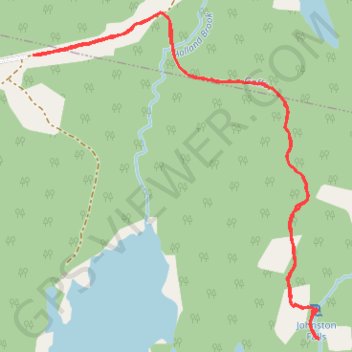
- Distance: 2.7 mi
- Elevation gain: 69 ft
- Maximum elevation: 279 ft
- Elevation loss: 69 ft
- Minimum elevation: 236 ft
- Moving time: 59 m 28 s
- Moving speed: 2.7 mph
- Maximum speed: 4.5 mph
- Total time: 1 h 34 m
- Global speed: 1.7 mph
Interactive trail map
Trail profile
- Distance: 2.7 mi
- Elevation gain: 69 ft
- Maximum elevation: 279 ft
- Elevation loss: 69 ft
- Minimum elevation: 236 ft
- Moving time: 59 m 28 s
- Moving speed: 2.7 mph
- Maximum speed: 4.5 mph
- Total time: 1 h 34 m
- Global speed: 1.7 mph
About this trail
Name: Johnson River Falls trail, distance, elevation, map, profile, GPS track
Coordinates: 44.82716 -63.57527 44.83753 -63.56243
Other hiking, mountain biking, running and outdoor activity trails
Click on a trail to view its statistics, map and profile.
Brookfield - Halifax
Canada > Nova Scotia > Municipality of Colchester > Brookfield
Distance: 57.3 mi • Elevation gain: 2,159 ft • Maximum elevation: 217 ft