Lake Niapenco Trail
Lake Niapenco. Binbrook Conservation Area. #Hiking #Running #Snowshoeing #Loop #Niapenco
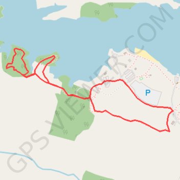
- Distance: 2.3 mi
- Elevation gain: 79 ft
- Maximum elevation: 682 ft
- Elevation loss: 79 ft
- Minimum elevation: 656 ft
Interactive trail map
Trail profile
- Distance: 2.3 mi
- Elevation gain: 79 ft
- Maximum elevation: 682 ft
- Elevation loss: 79 ft
- Minimum elevation: 656 ft
About this trail
Name: Lake Niapenco Trail trail, distance, elevation, map, profile, GPS track
Start: Gatehouse Trail, Hamilton, Golden Horseshoe, Ontario, L0R 1C0, Canada (43.09779 -79.83045)
End: Gatehouse Trail, Hamilton, Golden Horseshoe, Ontario, L0R 1C0, Canada (43.09779 -79.83045)
Coordinates: 43.09652 -79.84501 43.10185 -79.83036
Other hiking, mountain biking, running and outdoor activity trails
Click on a trail to view its statistics, map and profile.
Niagara Falls - Hamilton
Canada > Ontario > Niagara Region > Niagara Falls
#Bike
Distance: 52.3 mi • Elevation gain: 1,762 ft • Maximum elevation: 686 ft