Import a GPX file

Forest walk along Loch Ard

#GB #Scotland

  • Distance: 8.7 mi
  • Elevation gain: 1,004 ft
  • Maximum elevation: 381 ft
  • Elevation loss: 1,004 ft
  • Minimum elevation: 115 ft
  • Moving time: 3 h 23 m
  • Moving speed: 2.6 mph
  • Maximum speed: 4.4 mph
  • Total time: 4 h 15 m
  • Global speed: 2.0 mph

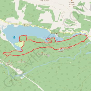
Interactive trail map

Trail profile

  • Distance: 8.7 mi
  • Elevation gain: 1,004 ft
  • Maximum elevation: 381 ft
  • Elevation loss: 1,004 ft
  • Minimum elevation: 115 ft
  • Moving time: 3 h 23 m
  • Moving speed: 2.6 mph
  • Maximum speed: 4.4 mph
  • Total time: 4 h 15 m
  • Global speed: 2.0 mph

About this trail

Name: Forest walk along Loch Ard trail, distance, elevation, map, profile, GPS track

Start: Pass of Aberfoyle, Milton, Stirling, Scotland, FK8 3TF, United Kingdom (56.18058 -4.41721)

End: Pass of Aberfoyle, Milton, Stirling, Scotland, FK8 3TF, United Kingdom (56.18049 -4.41740)

Coordinates: 56.17082 -4.49720 56.18234 -4.41685

Other hiking, mountain biking, running and outdoor activity trails

Click on a trail to view its statistics, map and profile.

Munro hillwalk Meall Dearg Sgorr nam Fiannaidh Aonach Eagach

United Kingdom > Scotland > Highland

#Munro #hillwalk #Meall #Dearg #Aonach #Eagach

Distance: 107.8 mi • Elevation gain: 9,564 ft • Maximum elevation: 3,156 ft

Gear up for your next adventure:

🎒Trekking Poles - Sturdy poles for balance and stability on rough terrain
💧Water Purification System - Clean water on the trail with reliable purifiers
🪶Survival Guide Book - Expert advice for emergency preparedness
👟Trail Running Shoes - Lightweight shoes for trail runners
🌲Outdoor Survival Books - Best books on survival skills

As an Amazon Associate, this site earns from qualifying purchases at no extra cost to you.