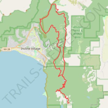
Tahoe Rim Trail (TRT) - Marlette Peak - Incline Flume
- Distance: 28.9 mi
- Elevation gain: 4,531 ft
- Maximum elevation: 8,825 ft
- Elevation loss: 4,534 ft
- Minimum elevation: 7,457 ft
- Moving time: 3 h 41 m
- Moving speed: 7.8 mph
- Maximum speed: 27.2 mph
- Total time: 4 h 17 m
- Global speed: 6.7 mph
Interactive trail map
Trail profile
- Distance: 28.9 mi
- Elevation gain: 4,531 ft
- Maximum elevation: 8,825 ft
- Elevation loss: 4,534 ft
- Minimum elevation: 7,457 ft
- Moving time: 3 h 41 m
- Moving speed: 7.8 mph
- Maximum speed: 27.2 mph
- Total time: 4 h 17 m
- Global speed: 6.7 mph
About this trail
Name: Tahoe Rim Trail (TRT) - Marlette Peak - Incline Flume trail, distance, elevation, map, profile, GPS track
Coordinates: 39.18663 -119.93838 39.30099 -119.89578
Topography: Washoe County topographic map, elevation, terrain
Other hiking, mountain biking, running and outdoor activity trails
Click on a trail to view its statistics, map and profile.
Monkey Rock via Tunnel Creek Road in Lake Tahoe Nevada State Park
United States > Nevada > Washoe County > Incline Village-Crystal Bay
The hike to Monkey Rock in Lake Tahoe Nevada State Park is a short but moderately challenging trail that rewards you with stunning panoramic views of the lake. Starting near Tunnel Creek Café, the trail climbs steadily through a mix of forest and exposed terrain, offering great lookout points along the way.…
Distance: 2.5 mi • Elevation gain: 512 ft • Maximum elevation: 6,765 ft
Monkey Rock Trail in Lake Tahoe Basin Management Unit
United States > Nevada > Washoe County > Incline Village-Crystal Bay
The Monkey Rock Trail via Tunnel Creek Road in the Lake Tahoe Basin Management Unit is a scenic, moderately challenging hike that offers hikers beautiful views of the surrounding wilderness. As you ascend, the trail provides expansive views of Lake Tahoe's azure waters framed by the surrounding Sierra Nevada…
Distance: 2.6 mi • Elevation gain: 509 ft • Maximum elevation: 6,762 ft
Day 1: Home to dispersed camping 60 mi E of Austin, NV
United States > Nevada > Washoe County > Reno
Distance: 129.5 mi • Elevation gain: 3,320 ft • Maximum elevation: 5,128 ft
Tahoe Rim Trail (TRT) - Marlette Peak - Flumes
United States > Nevada > Washoe County > Incline Village-Crystal Bay
Distance: 30.9 mi • Elevation gain: 4,629 ft • Maximum elevation: 8,825 ft
Tahoe Rim to Washoe from Mount Rose Highway
United States > Nevada > Washoe County
Distance: 17.7 mi • Elevation gain: 4,859 ft • Maximum elevation: 9,324 ft