Tahoe Rim to Washoe from Mount Rose Highway
- Distance: 17.7 mi
- Elevation gain: 4,859 ft
- Maximum elevation: 9,324 ft
- Elevation loss: 4,859 ft
- Minimum elevation: 5,217 ft
- Moving time: 5 h 44 m
- Moving speed: 3.1 mph
- Maximum speed: 8.1 mph
- Total time: 6 h 11 m
- Global speed: 2.9 mph
Interactive trail map
Trail profile
- Distance: 17.7 mi
- Elevation gain: 4,859 ft
- Maximum elevation: 9,324 ft
- Elevation loss: 4,859 ft
- Minimum elevation: 5,217 ft
- Moving time: 5 h 44 m
- Moving speed: 3.1 mph
- Maximum speed: 8.1 mph
- Total time: 6 h 11 m
- Global speed: 2.9 mph
About this trail
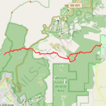
Name: Tahoe Rim to Washoe from Mount Rose Highway trail, distance, elevation, map, profile, GPS track
Start: Mount Rose Highway, Washoe County, Nevada, United States (39.30073 -119.92016)
End: Tahoe Rim Trail Connector, Washoe County, Nevada, United States (39.30082 -119.91982)
Coordinates: 39.28904 -119.94869 39.30520 -119.83400
Topography: Washoe County topographic map, elevation, terrain
Other hiking, mountain biking, running and outdoor activity trails
Click on a trail to view its statistics, map and profile.
Day 1: Home to dispersed camping 60 mi E of Austin, NV
United States > Nevada > Washoe County > Reno
Distance: 129.5 mi • Elevation gain: 3,320 ft • Maximum elevation: 5,128 ft
Tahoe Rim Trail (TRT) - Marlette Peak - Incline Flume
United States > Nevada > Washoe County > Incline Village-Crystal Bay
Distance: 28.9 mi • Elevation gain: 4,531 ft • Maximum elevation: 8,825 ft
Tahoe Rim Trail (TRT) - Marlette Peak - Flumes
United States > Nevada > Washoe County > Incline Village-Crystal Bay
Distance: 30.9 mi • Elevation gain: 4,629 ft • Maximum elevation: 8,825 ft