Make a donation
Gear up for your next adventure:
As an Amazon Associate, this site earns from qualifying purchases at no extra cost to you.
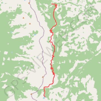
Great Divide Trail Window Mountain Lake to North Racehorse Creek
- Distance: 11.6 mi
- Elevation gain: 3,035 ft
- Maximum elevation: 7,352 ft
- Elevation loss: 3,714 ft
- Minimum elevation: 5,827 ft
- Moving time: 5 h 51 m
- Moving speed: 2.0 mph
- Maximum speed: 6.5 mph
- Total time: 5 h 59 m
- Global speed: 1.9 mph
Interactive trail map
Make a donation
Gear up for your next adventure:
As an Amazon Associate, this site earns from qualifying purchases at no extra cost to you.
Trail profile
- Distance: 11.6 mi
- Elevation gain: 3,035 ft
- Maximum elevation: 7,352 ft
- Elevation loss: 3,714 ft
- Minimum elevation: 5,827 ft
- Moving time: 5 h 51 m
- Moving speed: 2.0 mph
- Maximum speed: 6.5 mph
- Total time: 5 h 59 m
- Global speed: 1.9 mph
Make a donation
Gear up for your next adventure:
As an Amazon Associate, this site earns from qualifying purchases at no extra cost to you.
About this trail
Name: Great Divide Trail Window Mountain Lake to North Racehorse Creek trail, distance, elevation, map, profile, GPS track
Start: Ward / Allison Route, Municipal District of Ranchland No. 66, Alberta, Canada (49.76152 -114.63808)
End: Municipal District of Ranchland No. 66, Alberta, Canada (49.85354 -114.62807)
Coordinates: 49.76152 -114.64020 49.85354 -114.61972
Make a donation
Gear up for your next adventure:
As an Amazon Associate, this site earns from qualifying purchases at no extra cost to you.
Other hiking, mountain biking, running and outdoor activity trails
Click on a trail to view its statistics, map and profile.
Great Divide Trail North Racehorse Creek to Dutch Creek Tornado Pass
Canada > Alberta > Municipal District of Ranchland No. 66
Distance: 9.5 mi • Elevation gain: 1,998 ft • Maximum elevation: 6,476 ft