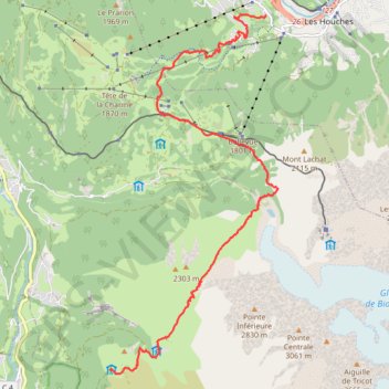
Day 01: Les Houches to Auberge du Truc
- Distance: 8.8 mi
- Elevation gain: 4,856 ft
- Maximum elevation: 6,946 ft
- Elevation loss: 2,549 ft
- Minimum elevation: 3,353 ft
- Moving time: 4 h 30 m
- Moving speed: 1.9 mph
- Maximum speed: 3.5 mph
- Total time: 8 h 5 m
- Global speed: 1.1 mph
Interactive trail map
Trail profile
- Distance: 8.8 mi
- Elevation gain: 4,856 ft
- Maximum elevation: 6,946 ft
- Elevation loss: 2,549 ft
- Minimum elevation: 3,353 ft
- Moving time: 4 h 30 m
- Moving speed: 1.9 mph
- Maximum speed: 3.5 mph
- Total time: 8 h 5 m
- Global speed: 1.1 mph
About this trail
Name: Day 01: Les Houches to Auberge du Truc trail, distance, elevation, map, profile, GPS track
Coordinates: 45.83546 6.74938 45.89259 6.78754
Other hiking, mountain biking, running and outdoor activity trails
Click on a trail to view its statistics, map and profile.
Ultra-Trail du Mont Blanc (UTMB)
France > Auvergne-Rhône-Alpes > Upper Savoy > Chamonix-Mont-Blanc
Distance: 104.2 mi • Elevation gain: 34,285 ft • Maximum elevation: 8,317 ft
UTMB 2020
France > Auvergne-Rhône-Alpes > Upper Savoy > Chamonix-Mont-Blanc > Les Bossons
Total: 171.3km
Distance: 104.5 mi • Elevation gain: 34,534 ft • Maximum elevation: 8,445 ft
TTdMB-1 Tour Du Mont Blanc - Itinéraire Principal
France > Auvergne-Rhône-Alpes > Upper Savoy > Chamonix-Mont-Blanc
Distance: 103.1 mi • Elevation gain: 34,564 ft • Maximum elevation: 8,323 ft
PT23DS2 Lörrach → Cadaqués
Germany > Baden-Württemberg > Landkreis Lörrach > Lörrach (Kernstadt)
Distance: 652.9 mi • Elevation gain: 43,077 ft • Maximum elevation: 4,938 ft