Sugarloaf Scenic Reserve Loop
Interactive trail map
Trail profile
- Distance: 3.0 mi
- Elevation gain: 1,053 ft
- Maximum elevation: 1,496 ft
- Elevation loss: 1,024 ft
- Minimum elevation: 1,079 ft
About this trail
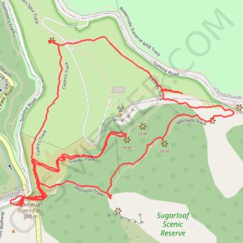
Name: Sugarloaf Scenic Reserve Loop trail, distance, elevation, map, profile, GPS track
Coordinates: -43.60658 172.64470 -43.60124 172.65447
Other hiking, mountain biking, running and outdoor activity trails
Click on a trail to view its statistics, map and profile.
Halswell River
New Zealand > Canterbury > Christchurch City > Banks Peninsula Community
Distance: 42.8 mi • Elevation gain: 1,050 ft • Maximum elevation: 131 ft