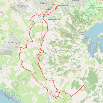
Halswell River
- Distance: 42.8 mi
- Elevation gain: 1,050 ft
- Maximum elevation: 131 ft
- Elevation loss: 1,047 ft
- Minimum elevation: 7 ft
- Moving time: 3 h 9 m
- Moving speed: 13.5 mph
- Maximum speed: 27.8 mph
- Total time: 3 h 10 m
- Global speed: 13.5 mph
Interactive trail map
Trail profile
- Distance: 42.8 mi
- Elevation gain: 1,050 ft
- Maximum elevation: 131 ft
- Elevation loss: 1,047 ft
- Minimum elevation: 7 ft
- Moving time: 3 h 9 m
- Moving speed: 13.5 mph
- Maximum speed: 27.8 mph
- Total time: 3 h 10 m
- Global speed: 13.5 mph
About this trail
Name: Halswell River trail, distance, elevation, map, profile, GPS track
Coordinates: -43.73153 172.50537 -43.57711 172.65253
Other hiking, mountain biking, running and outdoor activity trails
Click on a trail to view its statistics, map and profile.
Birdlings Flat Gravel/Unpaved Cycling
New Zealand > Canterbury > Christchurch City > Banks Peninsula Community
Distance: 13.3 mi • Elevation gain: 364 ft • Maximum elevation: 125 ft
Rapaki Track via MTB Singletrack
New Zealand > Canterbury > Christchurch City > Christchurch
Distance: 8.2 mi • Elevation gain: 1,312 ft • Maximum elevation: 1,089 ft
Afternoon Mountain Bike Ride
New Zealand > Christchurch City > Christchurch
Distance: 11.2 mi • Elevation gain: 1,480 ft • Maximum elevation: 1,089 ft